


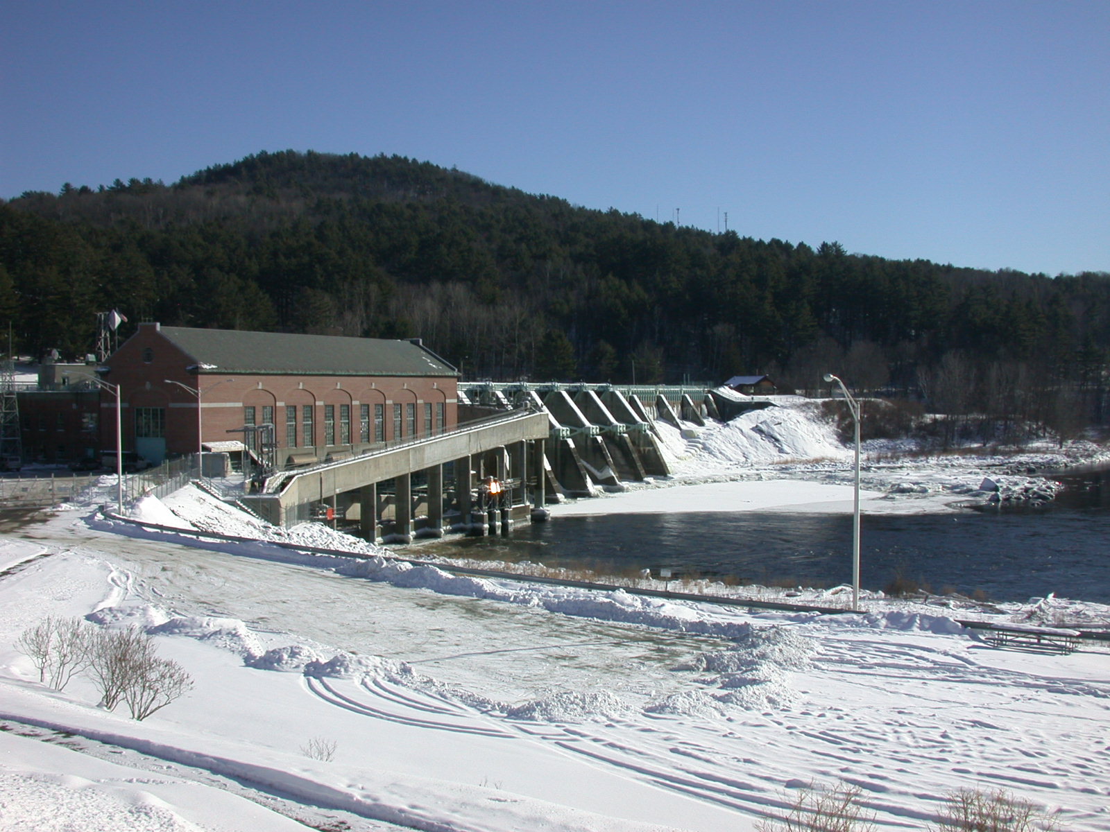
Wilder Dam, the major hydro power dam influencing the Connecticut River in the Upper Valley, straddles the river between Lebanon and Hartford. The dam impounds (backs up) the river for 45 miles upstream, and receives drainage from a 3,375- square-mile watershed in New Hampshire and Vermont. Wilder’s three turbines have a combined generating capacity of 42 megawatts.
The Hanover Conservancy has submitted comments to the Federal Energy Regulatory Commission on the Amended Final License Application for Wilder Dam. The Conservancy owns and manages the Mink Brook Nature Preserve and the Lower Slade Brook Natural Area which are directly affected by operations at Wilder Dam. While the Conservancy applauds the proposed operational change from a daily peaking cycle to an inflow=outflow model that more closely reflects the natural flow of the river system, strong concerns remain:
- Great River Hydro’s assertion that project operations are not contributing to erosion is not credible. Long-term bank erosion monitoring and mitigation are needed.
- Hanover residents do not have adequate recreational access to the river. Assistance to communities is needed to provide river-related recreational opportunities.
- The need for headwater and tributary conservation is urgent and requires a mitigation fund. It should be central to the mission of both Great River Hydro and FERC to help protect our region against the worst effects of climate change, including protecting the natural hydrology and forest cover of the watershed. Such efforts also benefit company operational planning by assuring a more predictable streamflow.
Connecticut River Management Plan’s Recommendations for Wilder Dam
The Federal Energy Regulatory Commission (FERC) should
- institute a “ramping rate” at Wilder Dam in the next operating license, to reduce soil piping in the riverbanks of the impoundment and to minimize negative effects on aquatic and riparian habitat.
- include a provision for emergency gate operation, such as in the context of a “black start” when the dam is needed to provide immediate power in case of a blackout.
- assess possible effects of sediment build-up behind Wilder Dam and the extent to which it has affected flood storage capacity.
- require the company to maintain discharge at run of river levels at periods of low flow in the next FERC license, to protect aquatic life downstream.
- Local citizen groups should participate in the re-licensing process for Wilder Dam.
References
- We share historical licensing and amendment information below, gathered from the Great River Hydro Wilder Dam page. A full history of the dam’s amendments and a map of all GRH sites can be found on that site.
- For background on Wilder Dam and its influence on the Connecticut River system in our area, we share excerpts from the Connecticut River Water Resources Management Plan for the Upper Valley Region, published by the Connecticut River Joint Commissions in 2009. This plan, created by citizens of Hanover and other NH river towns from Lebanon to Piermont and their Vermont neighbors from Hartford to Bradford, is a blueprint for stewardship of the Connecticut River. For information about the Connecticut River Joint Commissions and the Connecticut River Management Plan, contact Rachel Ruppel at the Upper Valley Lake Sunapee Regional Planning Commission (UVLSRPC): 603-448-1680. Find the full plan on the web at www.crjc.org.

Relicensing updates from the Connecticut River Conservancy
Resources
- Great River Hydro – Wilder Dam
- Wilder Dam Flowcast
- Contact Great River Hydro
- Contact CT River Conservancy re:
Great River Hydro facilities:
Kathy Urffer
kurffer@ctriver.org
(802) 258-0413 - CT River Joint Commissions
- Hanover Conservancy’s previous public comment on the relicensing of Wilder Dam (Feb. 2013)
Great River Hydro, LLC currently owns the license for operations at Wilder Dam.
On April 22, 1944, the original Wilder Project license was issued to the Bellows Falls Hydro-Electric Corporation by the Federal Energy Regulatory Commission (FERC) with the intent to construct a new integrated powerhouse and concrete dam 0.5 mile downstream of an existing dam, powerhouse and paper mill complex known as the Olcott Falls mill. After the July 28, 1948, license transfer to New England Power Company, reconstruction of the present-day Wilder Project began in March 1949 and commenced operations on December 1, 1950.
On February 27, 1998, FERC approved the transfer of the license from New England Power Company to USGen New England, Inc. Under a multi-license amendment dated November 19, 1998, regional electrical transmission facilities were removed from the Project, including step up transformers. At that time, the station was automated and began operations via remote control from the Connecticut River Control Center in Wilder, Vermont.
On January 24, 2005, FERC approved the transfer of the license to TransCanada Hydro Northeast Inc.
On April 19, 2017, Great River Hydro, LLC acquired all of TransCanada’s New England hydroelectric power portfolio which included the Wilder Project.
The federal operating license for Wilder Dam expired in 2018. Requests for ecological studies, and deadline extensions mean that the relicensing process is still ongoing, as of this writing (May 14, 2020).
According to the Connecticut River Conservancy, the companies had been expected to submit final “revised” applications in April, but Great River Hydro has an extension until July 31 and FirstLight until August 30th, 2020.
Wilder Dam occupies the former site of Olcott Falls, a pair of natural falls which were over 650 feet long and 40 feet high. In 1810 a canal with locks was built on the New Hampshire side to allow canal boats and rafts to pass around the falls. The first dam across the Connecticut here was an 808-foot cribwork dam at the upper falls, built in 1882. A new concrete dam followed just downstream in 1927. Wilder Dam, built in 1950 three quarters of a mile below the cribwork dam, flooded both of the original dam sites. On April 19, 2017, Great River Hydro, LLC acquired all of TransCanada’s New England hydroelectric power portfolio, which included the Wilder Project. Its current federal operating license expired in 2018 along with those of Bellows Falls and Vernon Dams.
Wilder Dam impounds the river for some 45 miles to Newbury and Haverhill. Because Wilder impounds such a long section, the power company releases water at the dam when high flows are expected from upstream. Public safety is a prime concern, and the company uses loudspeaker announcements when gates are opened, plus flashing lights and signs. The phenomenon known as “pond tilt” allows water levels to be very low near the dam, yet quite high some miles upstream. This occurs because it takes time for water arriving at the upstream end of the impoundment to reach the area of the dam.

Fluctuations in discharge at Wilder Dam create daily water level changes in the river, measured at the West Lebanon gage just below the dam, August 2006
A “daily peaking” hydropower generation plant, Wilder Dam raises and lowers water in the Wilder impoundment as it stores and releases water during the day. The timing and amount of this release depends upon flow conditions in the river and upon market price for electricity. While the dam’s current federal license conditions allow water behind the dam to fluctuate by as much as five feet [from an elevation of 380 to 385 feet above mean sea level], the water usually rises and falls within a narrower range. During the summer, the company operates Wilder Dam within narrower limits to benefit recreational use.
Wilder Dam was designed to handle flows of 162,000 cubic feet per second, the size of the 1927 flood. Since the dam’s construction in 1950, the largest recorded flow was only 55,000 cfs. Wilder Dam includes three turbines, one on the Vermont side of the river, and two on the New Hampshire side; they are the original units that were installed in 1950. The company uses vegetable oils for hydraulic lubricants in its machinery. The 1978 license issued by the Federal Energy Regulatory Commission (FERC) required upstream and downstream fish passage at this dam, Bellows Falls, and Vernon, and it was installed at a total cost of $40 million.
“Black Start”
Unlike power plants using non-renewable energy sources, hydro dams can provide a “cold or black start” to the electrical grid, as Wilder Dam and others on the Connecticut River did during the historic widespread blackout of the Northeast in 1965.A small generator provides enough power to open the gates, allowing water flowing through them to produce power first to re-start other power plants throughout New England, and then for consumers.
The construction of Wilder Dam resulted in several benefits to the river and its corridor. It provides energy without using fossil fuels, and contributes to the tax base of the towns in which it is located. By inundating tributary mouths and other low-lying areas, the dam created ecologically rich backwaters and wetland areas such as Wilder Wildlife Management Area in Lyme, the Ompompanoosuc flats in Norwich, and Reed’s Marsh in Orford, which provide habitat especially for waterfowl, warm water fish, and other wildlife. The flatwater pool behind the dam provides deeper water for power boating and other forms of recreation, which was not possible on the river until the dam was built, although the dam itself forces paddlers to portage their craft. Local people recall that it was possible to wade across the river from Bradford to Piermont before the dam was built. The dam also provides a way to influence flooding, ice breakup, and flows in time of drought.

When an impoundment is created by a dam, however, it alters the natural character of the river and changes the pattern of flow, so that the river behaves more like a lake. Water temperatures increase as a result of the greater surface exposure to sunlight, leading to reduced dissolved oxygen and reducing habitat quality for trout and other coldwater fish. Fish populations shift to warmwater species, and walleye, perch, and bass now inhabit the warmer water of the Wilder impoundment, using the shallows of tributary setbacks for spawning. Nutrients and contaminants may accumulate as they are not as quickly flushed, and some sediment and toxic substances may settle out in the quieter water. Because the dam can alter patterns of flooding and sediment deposition, some floodplains no longer function as before, although they are still essential.
Regularly fluctuating water levels are a particular concern in the Wilder impoundment. While there are many causes of riverbank erosion, the second most important in this region, as determined by the U.S. Army Corps of Engineers, is water level fluctuations from operations at Wilder Dam. The primary cause is natural scour. Rapidly changing water levels can cause pressure imbalances at the water-saturated bank face, causing water to seep out of the bank, carrying small particles of soil with it. This is called “soil piping,” and it can contribute to bank collapse. Water level changes also magnify the area of riverbank face that is exposed to erosive wave action.

Several years ago, an Upper Valley River Subcommittee member discovered a disturbing feature of some parts of the Hanover riverbank in the Wilder impoundment, where even heavily forested banks have been undercut, forming cavities that reach back five to six feet. Since these cavities remove physical and nutritive support for the trees above, they could result in bank failure. The cause of these cavities, thought to be primarily wave action, deserves investigation, particularly because of the high economic and aesthetic value of the riverfront in this region.
Riverfront landowners and other observers have reported that in recent years, and particularly since TransCanada acquired the Connecticut River dams, the level of the Wilder impoundment seems to show more pronounced variation than in years past, with higher high water levels and lower lows, with more rapid draw-downs. This creates concern for riverbank stability and sedimentation. The company is required to operate within the terms of the dam’s federal license, raising and lowering the water level within limits, but subtle shifts in management of this dam seem to be exploring the full range of allowable limits, rather than the more moderate regime of prior years. For this dam, the [current] license also does not spell out a “ramping rate,” or how quickly the impoundment can be raised or lowered, so there is no regulatory provision for gradual changes.
Related Articles
| New website for Great River Hydro | February 1, 2021 |
| NHPR Features Wilder Dam Relicensing Project | June 2, 2018 |
