 DOWNLOAD FULL PDF OF DIRECTIONS – Mink Brook & Tanzi Tract
Driving directions:
- From downtown Hanover, drive S on Main St. (Rte 10) 0.5 miles to Brook Rd.
- Turn L just before Route 10 crosses Mink Brook.
- Follow Brook Road for 0.1 mile to a sharp bend.
- Park here near the trailhead gate.
What you should know:
- Dogs are welcome but must be under close control (better yet, leashed); please pick up after your pet.
- Foot travel only. Bicycles are not permitted in the Mink Brook Nature Preserve.
- Trail maps are available at the trailhead kiosk near the Brook Road gate.
- The Preserve is home to bears who may emerge from hibernation as early as March (another reason to leash your dog). If you encounter a bear, do not run but speak softly to it and move away slowly. Mother bears are as protective of their young as we are.
- You will visit the 112-acre Mink Brook Nature Preserve, owned and managed by the Hanover Conservancy since 1999, and the 15.8 acre Angelo Tanzi Natural Area, owned by the Town of Hanover.
BRIEF HIKING DIRECTIONS
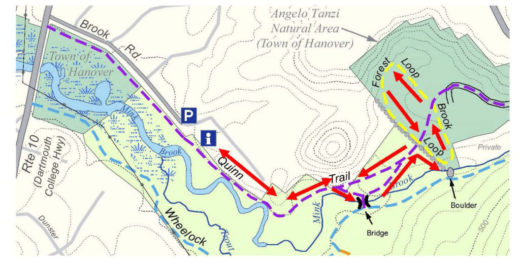
- Take the Quinn Trail through the gate and visit the kiosk.
- Continue on the Quinn Trail along the N side of Mink Brook, past the Norman Overlook.
- Bear R to view the brook, then bear L to return to the Quinn Trail. Turn R and up the hill.
- Enter the Tanzi Tract at a stone wall and turn R onto the Brook Loop. Follow back to Quinn Trail.
- Cross the Quinn Trail onto the Forest Loop and return along the stone wall.
- Turn R onto the Quinn Trail to return to your car.
FULL DIRECTIONS
- Pass through the gate onto the Quinn Trail. Take a moment to check the kiosk display just ahead and pick up a trail guide. Note the map outlining Mink Brook’s 18.5 square mile watershed.
- Hanover’s largest stream begins high on Moose Mountain at Mill Pond, gathering waters from other headwater streams and flowing through Etna, where it once powered so many mills that the village was first known as Mill Village. Below Etna, the brook turns and runs S of Greensboro Road through the Mink Brook Community Forest, protected in 2021. Crossing under Route 120 and past the remains of a mill built for Eleazar Wheelock, the brook rushes W past the Tanzi Tract and through the Mink Brook Nature Preserve toward the Connecticut River.
- You are walking the easy, flat Quinn Trail, named for a Hanover family we’ll hear about later. This part of the trail follows a buried sewer line marked by covers labeled “Hanover Sewer 1976.” While they seem out of place on a woodland walk, we can forgive the intrusion since the building of this sewer line to collect waste from hundreds of Hanover homes meant the transformation of Mink Brook and the Connecticut River from noxious open sewers back to the safe, clean waters they are today.
- Note the nature of the water in the brook. If ice-free, does it appear to be lazy and slow-moving, or is it locked silent under a cover of snow and ice? In this area, both the Connecticut and Mink Brook are pond-like, backed up behind Wilder Dam just downstream in Lebanon. Farther along the trail, stay alert for a change in character to the naturally free-flowing, musical stream that flows off the uplands.
- 5 minutes’ walk from the gate, the trail takes a sharp L by a crabapple tree. Pause here to note the thick, ropy stems of river grape (Vitis riparia) growing up the trees at L. This native vine is common along streams and offers a rich food source for birds and other wildlife.
- Now look R for a path heading towards the brook through young pines, and take a short trip down to the water where stepping stones offer a way to cross the brook at certain seasons. In the 1990s, a 30+ lot subdivision was laid out for the 112 acres of today’s Preserve. A road to serve the subdivision was to cross the brook here. Give a cheer for the 500 donors, the Quinn Family, and Dartmouth College for recognizing the natural value of this place and stepping up to help the Conservancy and Upper Valley Land Trust protect it. The Hanover Conservancy now owns and manages the land, with conservation deed restrictions from UVLT.
- Return to the Quinn Trail and note the exposed roots of a large tree on the steep bank opposite. This clay bank was mined at one time for clay that was used to build Dartmouth’s tennis courts!
 Turn R to continue on the Quinn Trail; you’ll soon arrive at the Norman Overlook at R, marked by slabs of granite offering a pleasant perch for observing the brook. Bob Norman, a founder of the Hanover Conservancy in 1961, was its President in 1999 when the Preserve was protected. A demonstration planting of native shrubs includes red osier (Cornus sericea), whose brilliant red stems are especially ornamental in late winter. This handsome shrub is a great choice for wet areas, as it tolerates wet feet and its white berries offer high quality food for wildlife in fall. You may see it growing naturally nearby.
- At this point, the brook is clearly more lively, with patches of open water roiled by its flow. Wilder Dam may be far out of sight, but it controls the character and movement of Mink Brook here in the Preserve and of other tributaries as far north as Haverhill NH and Newbury VT, 45 miles upstream. The Hanover Conservancy is closely following re-licensing of this dam and studies of how it affects erosion and sedimentation, fish, wildlife, invasive species, and even archeological sites. As this hike is published, a welcome new proposal from the hydropower company suggests altering dam management to more of a natural, run-of-river flow than an up-and-down “peaking” flow, meaning that more of Mink Brook would be allowed to behave like a proper stream instead of a pond.
- Note the stone riprap on the streambank near the tree line. Tropical Storm Irene sent so much water down Mink Brook that the brook changed course and began to erode this bank. Because the sewer line runs close by, the Town of Hanover is intervening to protect it from erosion.
- Just past this site, bear R off the Quinn Trail toward the old log crossing. The beautiful log bridge, crafted in 2009 from a nearby tree, served for over a decade to connect trails on the north and south sides of the Preserve. Mother Nature began to reclaim it and the crossing was closed in August, 2021 for public safety. From this point you can still enjoy views of the brook and a distinctive square-topped stone.
- Follow the path, bearing L at a fork to return up a short narrow path to rejoin the Quinn Trail. Turn R and take care on the stony slope as you approach the pine and hemlock forest on the hill above.
 Note the plaque at R honoring the Quinn Family, who helped protect this land in 1999. Both Brian and Allie Quinn were members of the Conservancy’s board of directors, with Allie leading environmental education efforts in Hanover schools in the 1970s and 80s.
- 5 minutes’ walk from the brook, arrive at a mossy stone wall marking the boundary with the Tanzi Tract. In 1966-67, working with the newly formed Conservation Commission, the Conservancy took an option on this 15.8 acre parcel and provided half the funding for its purchase for the Town. Angelo Tanzi (1899-1969) was a beloved local figure who managed a grocery market on Main Street (R), and whose family once owned this land.

- Turn R to follow the Brook Loop for a few minutes along the stone wall to a lookout over a particularly pretty section of Mink Brook.
- The Brook Loop bends left past a private inholding and returns in a few minutes’ walk to the Quinn Trail. Cross it to explore the 10-minute Forest Loop, marked “Foot Trail Only.”
- Soon, a wooded slope looms up ahead – one of the strangely steep sides of ancient channels of Mink Brook. This region was once inundated by the frigid waters of glacial Lake Hitchcock. Its fine sediments were easily sliced by the rushing waters of such brooks after the lake receded, leaving these ravines. The Storrs Road neighborhood, up out of sight on the terrace above, is set on part of the old lake bottom.
- The Forest Loop follows the base of the slope, bending L and passing over two boardwalks through great bear territory. In the hollow is a beautiful forested wetland that begins to hum with life in early spring. Note evergreen Christmas ferns and tipped-up trees in the wet soils.
- High quality habitat abounds here, for bears, wood frogs, and many other creatures and plants. In fact, the NH Fish and Game Department’s Wildlife Action Plan identifies this area as some of the highest quality habitat in the state, shown in pink on this map.
- The stone wall soon reappears at R. Keep a lookout for an old pine snag that gives an up-close-and-personal view of pine anatomy, branch collars and all.
- Return to the Quinn Trail and the Mink Brook Nature Preserve boundary sign on a large pine. Turn R and follow the trail down the hill, watching your footing and taking no turns.
- At the foot of the hill, the path may be damp with drainage from a wetland that is an extension of the one you skirted on the Forest Loop. This space is lively in spring with wood frogs and other amphibians courting and laying eggs.
- Continue W on the Quinn Trail past the Norman Overlook and kiosk to return to your car. As you do, note the change in character of the brook as it shifts from a free-flowing stream to one whose flow is captured by Wilder Dam.
- Be sure to come back as spring unfurls at the Preserve. This is a great walk at any time of year.
September 2021
This Hanover Hike of the Month is generously sponsored by


