DOWNLOAD FULL PDF OF DIRECTIONS – PineParkPerambulation
Driving directions: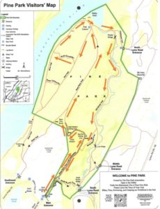
- From Hanover Green, go N on N. Main St.
- Continue straight onto Rope Ferry Rd.
- Park at the end of the road or near the clubhouse
What you should know:
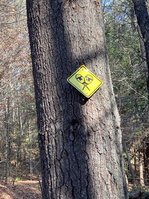
- Foot travel only. No bicycles.
- Dogs welcome if under close control. Keeping dogs off river and stream banks will protect against erosion. Please pick up after your pet.
- The hike explores a newly built all-person trail through open meadows and continues along the Connecticut River to an old-growth forest in the Girl Brook Gorge.
- Pine Park is the oldest conservation land in Hanover. The first 43 acres were purchased in 1899 by a group of 17 Hanover residents to prevent the Diamond Match Company from harvesting trees along the river.
- The park is owned by a private, non-profit Pine Park Association governed by a board of trustees, with representatives of the Town of Hanover and Dartmouth College. Seven acres of the former golf course (parts of holes 1, 5, and 18) occupied Pine Park property for a century.
- The Town of Hanover and Dartmouth College generously help to maintain the land. The Association receives no direct funding from the Town or College for conservation or maintenance. A major community fundraising effort has recently resulted in extensive improvements at the Park .
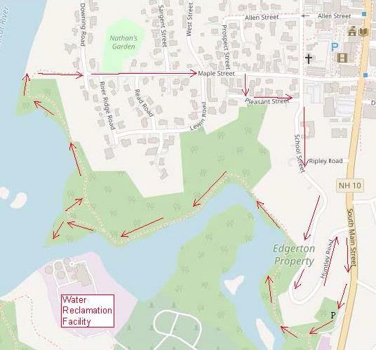
BRIEF HIKING DIRECTIONS
- Begin at the new stone gate and proceed 2100′ along the new accessible Rope Ferry Trail through a recovering golf course landscape.
- Continue straight on the Rope Ferry Trail into the forest and down to the Four Corners.
- Turn sharply L onto the Fern Trail.
- Turn R onto the North Connector Trail.
- Turn R onto the River Trail to Bailey Point at the Four Corners.
- Bear L downhill on the Girl Brook Trail and cross the Carolyn Tenney Bridge.
- Continue on the Girl Brook Trail and through the gorge, then bear R uphill onto the North Ravine Trail.
- Turn L onto the new Rope Ferry Trail and retrace your steps to return to your car.
FULL DIRECTIONS
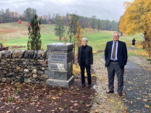
- Begin your hike at the handsome stone gate announcing your arrival at the newly reconfigured Pine Park entry. The park immediately presents you with the first of many contrasts, right beneath your feet: you’re stepping onto a Class IV road originally laid out in 1766, but rebuilt with three layers of gravel in 2022 to accommodate strollers, wheelchairs, and walkers of all ages.
- Pause for a moment to admire the handsome plantings of native trees and shrubs at the entrance, chosen for two-season color. Shadbush, viburnums, feathery amsonia, birch, and Stewartia replace invasive plants and scrubby growth. The stone gate, built by Standing Stone, is gathered with old-fashioned mortar. Stones are hand-chipped to fit, and the upright coping on the uppermost layer echoes a traditional method to make the wall stronger.
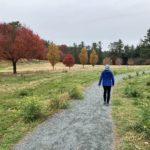
- Start down the gently arcing trail. The friendly path is a feat of engineering, requiring an investment of $185,000 raised in the community. Until recently, park users had to be very fit – quick enough to dodge flying golf balls and strong enough to deal with steep terrain. Today it’s possible to simply stroll. The 2100’ long trail allows everyone to venture deep into the park.
- Passing the corner of a neighbor’s new cobble wall, you step from the Class VI road onto park land. The Class VI section is 400 feet long. A flat area at L is the former 18th green, one of several removed by Dartmouth College after the golf course was closed and nine acres were returned to Pine Park. Back in 1913, after the Park Association signed an agreement with the college to manage the area, the growing golf course spilled over onto park land, which included a 7.5 acre gift from neighbor Emily Hitchcock. This agreement is being revised, along with boundary adjustments to benefit both. The result will be a natural Pine Park for all, consisting of 100 acres.
- A berm at L follows the presumed route of Old Ferry Road in this part of the park. Its exact path is unknown, and planners rely on a 1925 map drawn from memory by a college professor.
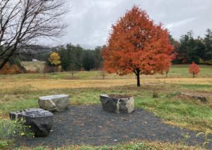
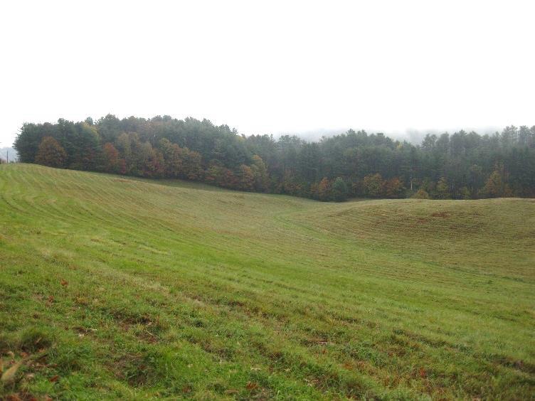
- 7 minutes’ walk from the entrance, arrive at an iconic pine tree with boulder benches at its feet. Pause to admire the sweeping view over the former golf course, where in mid-fall, red maples blaze on slopes mixed with the subtler tones of beech and red oak. The wind makes waves in the golden, newly planted grass. Here and there, new tree plantings attract birds and soften the transition to forest.
- Along the treeline, non-native buckthorn and honeysuckle are also attempting to colonize the area. The Park Association will work with natural resource consultant Redstart to control these invasives with a grant from the USDA Natural Resources Conservation Service. Restoring natural drainage on the former golf course is another task.
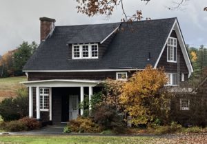 The Rope Ferry Trail makes a gentle U up to the L, providing a view of the former clubhouse. Art professor Homer Eaton Keyes designed the shingled Arts and Crafts-style structure around 1915 as a remodeling of an earlier “golf barn.” The building holds both charm and contamination. Asbestos and lead paint are among the challenges preventing its creative adaptation to a new use.
- Reach the rise in the path to discover another group of three boulder benches, arranged for conversation.
- Now it’s time to enter the woods and discover an entirely different face of Pine Park. As you do, check the
 forest floor at R for a patch of delicate sweet woodruff, whose starry white flowers will bloom in May.
 - Shortly past the transition to the wooded path, another trail enters at L; if you have lingered too long on the benches, this is your quickest route back to your car. To continue, stay straight on the route of Old Ferry Road.
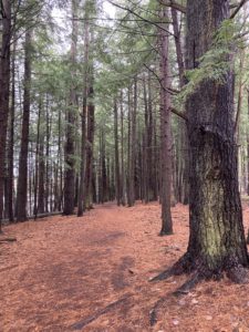
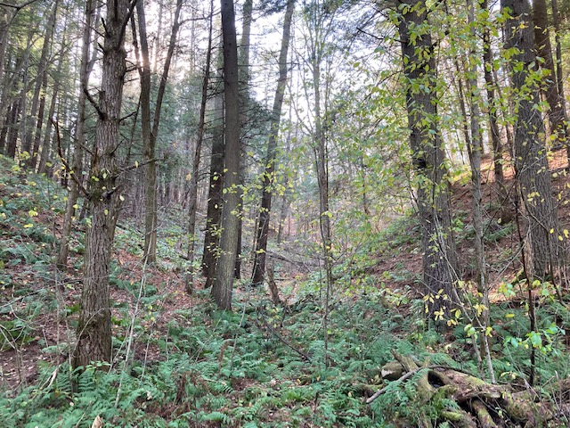
- The trail truly feels like a road as it leads you easily over the highest ridge in the park. Note the steep drop-offs to either side. Here and there, hazard trees have been felled to protect trail users. Tawny beech leaves decorate the nearly level trail until it begins to head down through a dense hemlock stand.
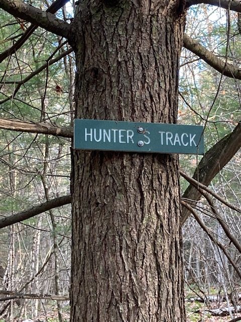
- Suddenly, the ancient road becomes even more obvious, its bed deeply incised in the soft soil. Laid out in 1766, five years after Hanover was incorporated, the road led to a rope-operated ferry across the Connecticut River that ran until 1786. A tavern waited on the Vermont side, and we can imagine Dartmouth students eager to try the crossing. It’s no surprise that it was the ambitious tavern keeper who sought the license to build the ferry. The ferry landing spot is unknown, but likely was at the sandy mouth of Girl Brook.
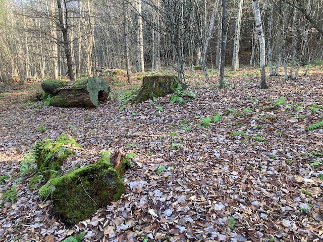
- Don’t miss the mound and pit topography of the forest floor at R. These lumps and depressions are characteristic of undisturbed forest, and are what remain many years after a tree blows down. The lifted root ball eventually decays to become a mound next to the pit where it used to rest. Some people call these “pillows and cradles.” By looking at one in relation to the other, you can tell what direction the wind was blowing when it took down the tree.
- Continue down the slope over a few waterbars built to keep runoff from eroding the trail. Long-time volunteer Ron Bailey built these. Bailey Point, ahead at the confluence of Girl Brook and the Connecticut, is named in his honor.
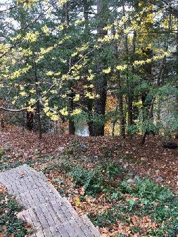
- About 10 minutes’ walk from the meadow, the river appears ahead. Look for a trail junction (signs coming soon) at L. At the foot of the hill take a sharp L onto the Fern Trail, heading S and away from the river. It’s time to explore yet another side of Pine Park. Invasive plants were removed here during the summer of 2022, and hay-scented ferns, briars, and other young sun-seeking growth are colonizing the opening made in this once cathedral-like part of the forest. Attacked by beetles and a needle-cast fungus, the tall pines that once stood here had become a danger in this heavily-used park, and were taken down in 2019 under the supervision of professional foresters. The decision was a difficult one for all. Merchantable sections were removed and branches were chipped, but many downed trunks remain, still storing the carbon they contain. The arrangement makes for tricky footing for deer, discouraging them from browsing new tree sprouts. Viable saplings will be protected with tubes. On the forest floor, patches of bearberry are increasing.
- 4 minutes from the last junction and just before the Fern Trail swings R ahead, turn R onto the new North Connector. This short trail is easy to follow, with its 15” thick log “guard rails.” About this open area, Pine Park Association President Linda Fowler says, “if Mother Nature doesn’t come up with seedlings soon, we will help her out.” Plans call for a grove of trees with a bench for quiet reflection.
- 4 minutes from the Fern Trail, arrive at a 3-stemmed pine at the junction with the River Trail. Again, if you’re running out of time, turn L here to return to your car.
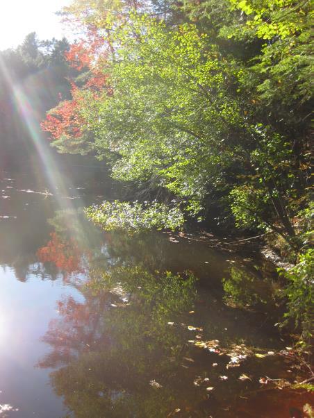
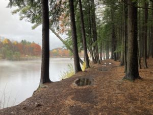
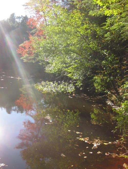
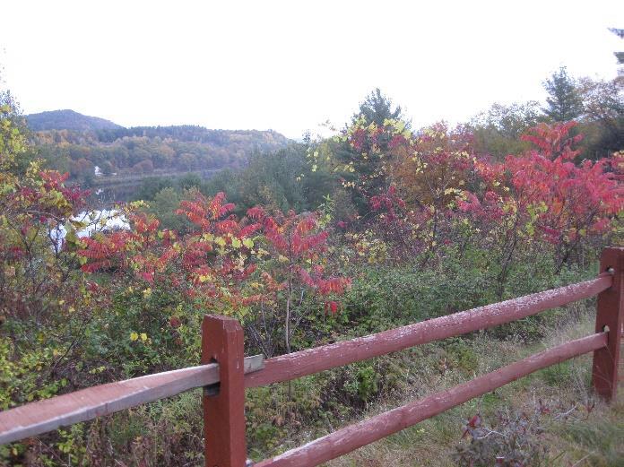
- To continue, turn R onto the most familiar part of Pine Park, where the trail hugs the river. Even the sounds of cars on Route 5 across the water can’t dim the pleasure of this path. In the late 1800s, the Diamond Match Company hoped to buy this patch of forest and literally turn it into matchsticks. Concerned locals stood up to the corporate giant and purchased 44 acres to create Pine Park, the very first conservation land in Hanover. Those burly would-be matchsticks have now reached a size that would catch the eye of old King George, who in the 1700s claimed every pine greater than 24” in diameter for the Royal Navy. “Mast pines” still stand tall here thanks to action by concerned citizens.
- A close look reveals the eroding riverbank. Pine Park, like other lands in the impoundment behind Wilder Dam, is affected by daily raising and lowering of the water for power production. Unlike other landowners, Pine Park has a long-standing agreement with the power company to protect its riverbanks, and work has been done to safeguard trees that might topple into the water and tear open the bank.
- Please stay away from the water’s edge – dogs, too – to keep from destabilizing the bank further.
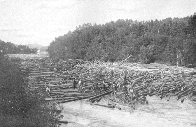
- Near the N end of the park, two rustic benches offer a chance to stop and enjoy the largest river in New England as it makes its way from a tiny beaver pond near the Canadian border through four states to Long Island Sound, a journey of 410 miles. It’s probably pretty peaceful today, but imagine what it might have 4 been like before the dam was built and the log drives went through here. You’d be able to walk over the logs to Vermont if you’d brought your spiked boots.
- Just S of the farthest bench is the Four Corners trail junction. From this point the Rope Ferry Trail you came down on appears up ahead. Instead, bear L and downhill amid slender yellow birches to the Girl Brook Trail.
- This soon flattens with Girl Brook at R and a river “setback” at L. Might the ferry landing have been here?
- A sewer manhole cover seems out of place in the middle of the trail, but reminds that in 1961, the line here prompted the Town of Hanover to plan a wastewater treatment plant here – at Pine Park! Wiser heads prevailed, and it was built instead at the mouth of Mink Brook.
- In the early 1900s, Emily Hitchcock gave additional land to Pine Park including the area you’re now walking.
- Erosion on the banks of Girl Brook has been a problem for years, evidenced by random squares of old sidewalk brought years ago to armor its bank. The Byrne Foundation recently gave $20,000 to shore up the brook-side trail in a more esthetically pleasing way.
- A few minutes’ walk from the Four Corners, the Firehouse Trail heads uphill at L; you bear R to cross the Carolyn Tenney Bridge. Carolyn was
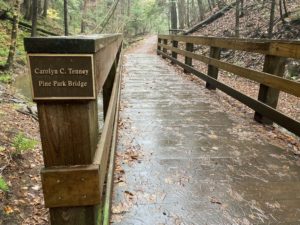 co-founder and first president of the Hanover Conservation Council, now the Hanover Conservancy. She lived on Rope Ferry Road, was a Town Commissioner for Pine Park, and was a lifelong conservationist. In their first project together, the Pine Park Association raised the funds for the bridge and the Town built it.
 - You’re now entering the most dramatic, ancient, and mysterious part of Pine Park, the Girl Brook Gorge. A lush variety of ferns blankets the slopes at right – delicate maidenhair and sturdy Christmas fern, as well as foamflower. Yellow birch, with its glistening golden bark, grows big and old among towering pines, hemlocks, and others. It’s noticeably cooler here in this steep and shady gash in the land, cut by Girl Brook in the 14,000 years since glacial Lake Hitchcock drained downriver. Slippery clay soils underfoot are remnants of lake-bottom sediments, easily sliced by a roaring brook. This gorge is 120’ deep in places, setting it apart from the world above. Imagine – Girl Brook once flowed far above your head!
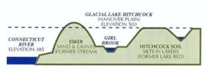
- The creator of this valley is the most hydrologically challenged stream in Hanover. Its small and intensively developed watershed reaches from CRREL to Balch Hill to the Dartmouth campus. Much of its watershed – except here – lost its natural forest cover more than 150 years ago. Think farmland followed by pavement, rooftops, rugby field, and golf course. At the former driving range on the E side of Lyme Road, swales show where this land sheds water toward the brook. Rain falling on this mowed or developed land has nowhere to go but run off, and can’t easily soak into the soil where it could feed the brook more consistently. During a drought and even in normal times between rains, the brook runs dry. A rainfall will drain through quickly, leaving the channel empty. Not a healthy thing for amphibians, fish, and other creatures that require
 year-round wet habitat.
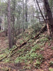
 - While Girl Brook may remind you of a well-landscaped storm drain, the towering slopes of its valley walls support something of wonder – a rare remnant of old growth forest. Too challenging for the axman, the forest remained largely untouched and now shows the variety of species, age classes, and structure that only develops over hundreds of years.
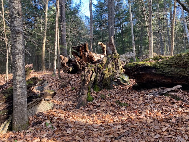
- About 10 minutes from the Tenney Bridge, arrive where recently cut hazard trees line the trail. Look L to see an immense, spidery root system of a large tree that has fallen across the brook.
- The valley begins to open up and you soon come to a fork in the trail. Bear R up a short, somewhat steep hill. Watch your footing – angular stones underfoot were placed to slow runoff down the path. Halfway up, a large cut stump at L offers a place to catch your breath.
- Pavement appears ahead as you emerge from the woods. At L is the site of the high bridge that once carried golfers across the gorge from one part of the old course to another. The 90-year old bridge was removed a few years ago for safety reasons.
- At the top of the rise, bear R at a fork to rejoin the Rope Ferry Trail in 25 paces.
- Turn L to return to your car. Consider how many communities you know with such places within walking distance of downtown – so diverse, from meadows to old growth forests, a major river, and a tiny stream. Pine Park is a true treasure.
October, 2022
Thanks to Linda and Steve Fowler of the Pine Park Association, and to the many friends and neighbors who contributed in so many ways to the rejuvenation of Pine Park.
Learn more at https://pinepark.org
Thanks to the Coop Food Stores’

program for supporting this hike of the month


 Driving Directions
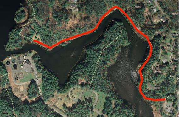


 Storrs Pond is part of what must be Hanover’s hardest working watershed – Camp Brook. This brook begins on lands owned in the 1800s by the Camp family that are now held by the Trescott Company (50% Town of Hanover, 50% Dartmouth College). The Hanover Water Works bought those lands in 1893-1912 to create the public water supply. Camp Brook was dammed in 1893 to form the Fletcher Reservoir (where Grasse and Reservoir Roads meet) and again in 1924 to form the Parker Reservoir upstream. After filtering, much of its water ends up on downtown restaurant tables, in college dorms, and domestic faucets. What’s left continues downhill along upper Reservoir Road and into another artificial pond created by a third earthen dam. We know this one as Storrs Pond, and thanks to the Hanover Improvement Society, there’s a lot of fun to be had here!