Balch Hill ~New Trails-full PDF
 Driving Directions
- From Downtown Hanover, take E. Wheelock St to Park St, turn L at light and R at next light onto Rte 10/Lyme Rd
- At first rotary, bear R onto Reservoir Rd
- Just past Ray School, turn R onto Hemlock Rd, pass Rip Rd, bear R at Y for Ledge Rd.
- Continue ½ mile up Hemlock Rd, around hairpin turn to its end at a private drive.
- Park in the circle here, being careful not to block the drive.
What You Should Know
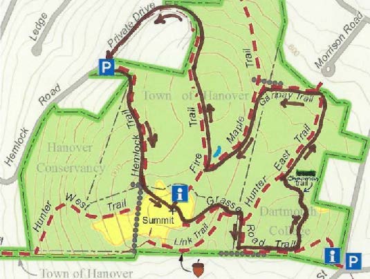
- This loop hike explores new and rebuilt trails on the Balch Hill Natural Area, with a stop at the summit to enjoy its beautiful views.
- You’ll be walking on lands owned by the Town of Hanover, Hanover Conservancy, and Dartmouth College. Some but not all of this land is permanently protected.
- Trails have occasional short up-and-down grades but are easy for the entire family.
- Archery hunting for deer is permitted Sept. 15-Dec. 15, when blaze orange is a good wardrobe choice.
- Dogs are welcome but must be under your control; please pick up after your pet.
Brief Directions
- Take the Hemlock Trail up over stone steps, across a stone wall, and up to the summit.
- Take the Grasse Road Trail down the E side, turning L at a stone wall.
- Bear L onto the Chapman Trail to a bench and eastern view.
- Continue to the Hunter East Trail and turn R.
- Bear L onto the Garipay Trail and L again onto the Maple Trail.
- Turn R onto the Fire Trail and follow it down to a driveway.
- Turn R and follow the drive back to your car.
Full Hiking Directions
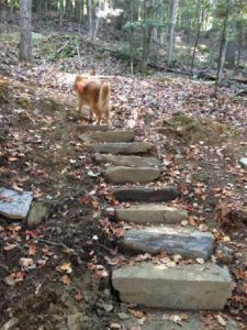 Begin your hike on the orange-blazed Hemlock Trail, marked by a brown sign with yellow lettering. A series of stone steps (R), terracing, and switchbacks help you navigate the steep (and in winter, icy!) beginning of the trail. In a fine example of partnership, the Upper Valley Trails Alliance’s high school trail crew built these steps in 2017, on land owned by the Town of Hanover with funds contributed to the Hanover Conservancy by the Chapman Family.
- Soon the trail straightens and passes through pleasant hemlock and pine woods.
- 7 minutes from your car, cross a fragment of an old stone wall. Look for the shells of 2 ancient maples at R. We’ll meet more of their fellows later.

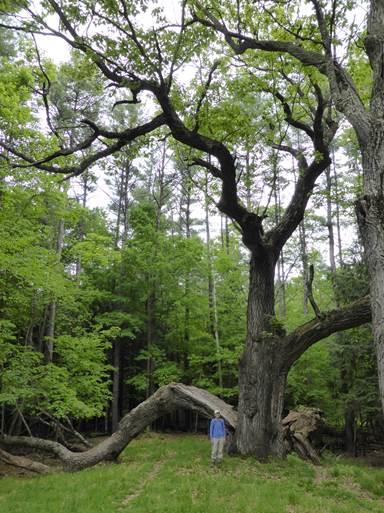
- You’ll soon come to the remains of an enormous old oak, its split trunk and massive limbs now draped across the landscape like an opened lily, having lost their battle with gravity and time. The trail passes under a fallen limb. Here’s what it looked like in 2014 (R).
- The trail continues up and L into an opening framed by old crabapple trees, and the summit bench comes into view.
- 12 minutes from your car, arrive at the summit kiosk, dedicated to neighbor and Hanover Conservancy volunteer educator Alice Jackson. Here, you can read about views and pick up a trail guide.
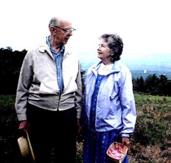
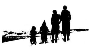 The bench honors one of Balch Hill’s most important benefactors, Ralph Hunter. Ralph, who took this photo of a young family skiing here in 1965, lived nearby and developed 7 building lots on Hemlock Rd. In 1970 he was instrumental in helping the Hanover Conservancy (then known as the Hanover Conservation Council) acquire 6.26 acres at the summit, donating some of his own land to bring it to 10.3 acres. Then in 2001, Ralph and his wife Betty (below) donated another 10 acres to the Council, protecting the W side of the hill.
-

Ralph and Betty Hunter Pay your respects to the fine summit maple, standing 920 feet above sea level – can you find the heart shaped pattern in its bark? From here, you can enjoy views as close as a monarch butterfly on milkweed at your feet or as far as Killington, 29 miles away. The stone bench was given in memory of Betty Latham.
- Continue your perambulation of Balch Hill by heading toward the balancing rock reminding that no fires are permitted here.
- The views of Mount Ascutney, four ridges to the southwest, are inspiring and hard-won. For over a century, the open, breezy summit of Balch Hill served as pasture first for sheep and later for cattle, but once the grazing stopped, Nature had other ideas and began to clothe the hill once again. By the 1990s, a threat lurked amid the puckerbrush – non-native invasive buckthorn, barberry, burning bush, and honeysuckle. Major grants to the Hanover Conservancy from USDA’s Natural Resources Conservation Service, plus private donations, paid to push back the invasives, improving wildlife habitat and restoring views. Resulting brush piles were tucked into the woods to provide cover for small mammals.
- Follow the red-blazed Grasse Road Trail down from the summit. The woods are quite different here on the S side of the hill – young hardwoods with some pine. As the trail bends L, look for a big maple snag at R. Its size compared to its companions is a clue that it once stood alone on an open slope.
- A few minutes’ walk from the summit, pass the “candelabra tree” at L – a dismembered pine with marvelous grain where its whorl of branches once met the trunk.
- The trail turns sharply R into a hollow at the Link Trail junction. Bear L on the Grasse Road Trail over the double log crossing, built by volunteers from Hypertherm.
- Soon the Hunter East Trail – named for Ralph Hunter – comes in at L. Bear R as the Grasse Road Trail follows a series of mossy ledges. Here on the SW side of the hill, the glacier plucked stones away from the ledge as it ground its way over. But where did they go?
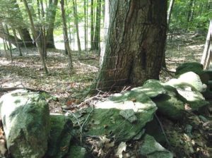 The answer appears in a few more paces – the settlers plucked them for stone walls! Straight ahead is the S boundary line, marked with an old wall topped with wide wire sheep fencing (R), relics of the mid-1800s. In 1840, over 10,000 sheep grazed on Hanover hillsides, including this one, while the human population stood at around 2,000.
- The trail swings L along the stone wall. Soon, at the top of a small rise, arrive at a Y with the Chapman Trail, marked with a sign at L. The Upper Valley Trails Alliance’s high school trail crew built this trail in 2017, again with a gift to the Conservancy from the Chapman family. The trail crosses Dartmouth land with the College’s permission.
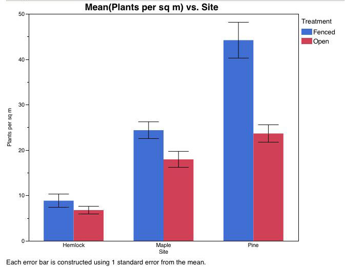
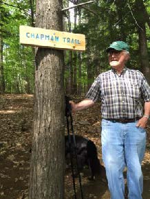 Turn L onto the purple-blazed Chapman Trail, which rises gently. In this area, Dartmouth ecology students conducted a study to determine the effect of deer browse on the vegetation. Two identical plots, one fenced against deer and the other unfenced, were compared each year. Results show that deer browse reduced the number of wildflowers, especially Canada mayflower.
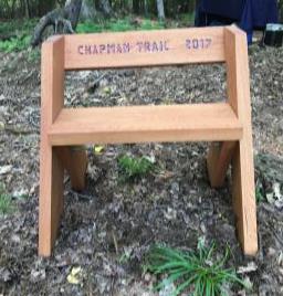 Soon you arrive at an Aldo Leopold bench, designed by the legendary conservationist himself and built of black locust by a Conservancy volunteer. The trail and bench are recent additions to Balch Hill, named for long-time Balch Hill neighbors. Rob Chapman (L), early chairman of the Balch Hill Stewardship Committee and former member of the Conservancy’s board of directors, had long envisioned a trail to this knoll, where views E to Moose Mountain are being opened up.
- Take a moment to relax on the bench and consider the many families that have been touched by Balch Hill – and those who have given back in return. Some might spend a morning helping to clear a trail, and others, like the Chapmans, Hunters, Stapleses, and Jacksons, have given deeply over many years in this and many other ways.
- Continue on the Chapman Trail as it curves L and re-enters the hemlock forest, winding gently down off the knoll. In 3 minutes, reach the blue-blazed Hunter East Trail, marked by a large downed hemlock.
- Check your watch – if you’re in a hurry to get back to your car, turn L here, take the Grasse Road Trail to the summit, and return on the Hemlock Trail the way you came (about 20 minutes).
- To continue exploring (30 minutes), turn R on the Hunter East Trail, through the gap in the fallen hemlock and down into a ferny glen. In 5 minutes, Morrison Circle appears between the trees and the trail swings L at a large red oak.
- Soon you’ll arrive at a sign for the Garipay Trail. The Garipay family farmed this area in the 1940s-70s, with land holdings that extended from Lyme Road to Grasse Road. Earle Garipay’s 185-cow dairy farm was based on Reservoir Road. Young stock were kept on Balch Hill.
- Head up the blue-blazed Garipay Trail, crossing a small wooden bridge built by another Conservancy volunteer over a little drainage that Is dry in fall. The trail continues along a fragment of stone wall and bears L uphill past rosettes of evergreen Christmas fern.
- 5 minutes’ walk from the Hunter East Trail, the Garipay Trail ends at the yellow-blazed Maple Trail. Bear L to continue uphill. Openings at R are tangles of raspberry canes thriving in the sunlight as several pines gave way. Soon you’ll pass among blowdowns from a sudden windstorm on Patriot’s Day, 2007. All the trees are laid to the SW, indicating that the wind came from the NE. Root systems, still clinging to rocks and soil, are tipped up and will melt into mounds next to the pits where they once grasped the earth. This “mound and pit” micro-topography is a common feature in New England woods, where it tells stories of forests past.
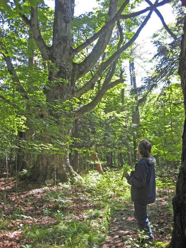
 5 minutes’ hike up the Maple Trail brings you within sight of the summit through the trees – and what magnificent trees they are! Now you know the story behind this trail’s name. Four enormous sugar maples, three still living, march in a line, the ancients standing out among their much younger brethren. A few more appear just ahead. How many people would it take to encircle one of these giants?
- These venerable maples, possibly 250 years old, may have marked one of Hanover’s earliest roads. Laid out in 1764, Half Mile Road passed just E of the summit of Balch Hill and ran parallel to and ½ mile E of the Connecticut River.
- A double blaze marks a turn to the R; ahead is the most marvelously gnarled maple of all.
- In a few more yards, reach the unmarked Fire Trail, a wide old farm lane. The summit is visible up the hill at L; across the way is the shell of yet another ancient maple.
- Turn R onto the Fire Trail – this time it’s a practical name – the Fire Department can use this old road to reach the summit in an emergency.
- At R is a curious depression that may be dry in fall but is full of water in spring. Earle Garipay dug this pit to provide water for his cattle; these days it serves as a vernal pool!
- Head down the Fire Trail; in 5 minutes, approach an opening that gives a broad view into Vermont. A blue arrow directs you R to skirt this privately owned former (and possibly future) house site. Soon the Fire Trail meets the drive. Turn R down the drive. A formal arrangement with the landowner provides for public foot access here. The dark hemlock forest at R reminds you what the N side of Balch Hill once looked like.
- The drive swings L and your car comes into view. Be careful to heed the cable across the end of the drive.


The volunteer Balch Hill Stewardship Committee cares for this place and always welcomes help.
Contact us if you’d like to get involved!
We welcome contributions to the Balch Hill Stewardship Fund
to help with the costs of annual mowing, vegetation management, and trail improvements.
October 2017; updated July 2020