Each month, we feature a new hike around Hanover for self-guided fun. Each hike includes directions on how to get to the trailhead, detailed turn-by-turn directions for following the route, land history and a vivid description of what you’ll find while you’re there. Access each hike on your phone (if cell service allows), or print the PDF version to take with you! Though we do our best to match each hike with its ideal season, most of these trails are suitable for year-round use: search by location or keyword here to find your next adventure!
Enter a hike name or keyword below to find a hike.
| Name | Distance | Elevation Gain | Difficulty | |
|---|---|---|---|---|
 |
Baum Conservation Area and Moose Mountain | 2.5 mile loop + 0.7 mile optional | 480 to 520 feet | Medium |
 |
Behemoths of Balch Hill | 0.8 miles round trip | 160 feet | Easy |
 |
Black Bear Loop | 1.05 miles round trip | 300 feet | Easy |
 |
Brook/River/Garden Loop | 2.2 miles | 180 feet | Medium |
 |
Camp Brook Valley Loop | 2 miles | 270 feet | Easy |
 |
Childs Farm Loop at Trescott Lands | 1.4 miles | 180 feet | Easy |
 |
Corey Road and the AT | 2 miles round trip | 350 feet | Easy |
 |
Fullington Farm & Old Highway 34 | 1.8 miles | 240 feet | Easy |
 |
General’s Trail | 2.3 miles round trip | 520 feet | Easy |
 |
Hayes Farm Park & Audrey McCollum Trail | 1.1 miles round trip | 150 feet | Easy |
 |
Historic Wolfeboro Road West | 2.8 miles one way | 600 feet | Medium |
 |
Hudson Farm & the AT | 1.75 miles round trip | 150 feet | Easy |
 |
Huntington Hill North Loop | 1.3 miles round trip | 120 feet | Easy |
 |
Kendal Riverfront Park and Rinker-Steele Natural Area | 1.2 mile loop | 360 feet | Easy |
 |
Mill Pond Forest & Dana Pastures | 2 miles | 50 feet | Easy |
 |
Mink Brook & Tanzi Tract | 1.5 | 50 | Easy |
 |
Mink Brook & the Harris Trail | 1.3 mile loop | 140 feet | Easy |
 |
Mink Brook and Gile Hill | 2.1 miles | 220 feet | Medium |
 |
Moose Mountain Lodge and Ledges | 1.9 miles round trip | 280 feet | Medium |
 |
Moose Mountain Ridge Loop | 4 miles round trip | 1,050 feet | Medium |
 |
New Trails and Old Names at Balch Hill | 1.1 mile loop | 300 feet | Easy |
 |
Oak Hill: Up, Down, Roundabout | 3.0 miles round trip | 370 feet | Medium |
 |
Old & New Etna Loop | 4.5 | 370 | Easy |
 |
Old Highway 38 & Hudson Farm | 2.6 miles round trip | 180 feet | Easy |
 |
Paine Road in the Trescott Lands | 2.0 miles round trip | 80 feet | Easy |
 |
Pasture Road Peregrinations | 3.5 Miles | 410 feet | Medium |
 |
Pine Park Perambulation | 2 miles | 150 feet | Easy |
 |
Rinker-Steele Natural Area | 2 miles round trip | 140 feet | Easy |
 |
Shumway Forest and Tom Linnell Ridge Trail | 4 miles round trip | 1,130 feet | Medium |
 |
Slade Brook and Huntington Hill | 2 miles round trip | 450 feet | Easy |
 |
Slade Brook Watershed Trails | 1.1 miles round trip | 250 feet | Easy |
 |
South Esker | 1.0 miles round trip | 80 feet | Easy |
 |
Storied Stones of the South Side | 1.75 | 30 | Easy |
 |
The Velvet Ledges of Greensboro Ridge | 1.5 miles round trip | 350 feet | Medium |
 |
The White Ledges of the Mayor-Niles Forest | 1.1 miles round trip | 400 feet | Medium |
 |
Trescott Trails: Knapp Road & Ascutney View | 2.6 miles round trip | 360 feet | Easy |
 |
Trescott/Paine/AT Loop | 3.4 mile loop | 600 feet | Easy |
 |
Tunis Brook Mill Lot | 1.1 miles round trip | 60 feet | Easy |
 |
Waterfalls of Slade Brook | 1.0 miles round trip | 200 feet | Easy |
 |
Wildflowers and Waterfalls | 2.5 miles | 300 feet | Easy |
This Month’s Hikes
Map of Hikes
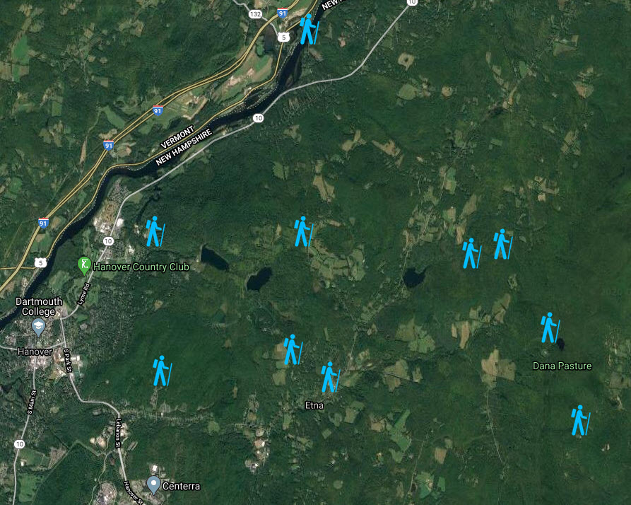
Map of Hikes


