An easy hike to hidden historic sites.
Distance: 2 miles round trip
Elevation gain: 350 feet
Time: 1.25 hours
Categories: Hike of the Month, March
Tags: Appalachian Trail, Class VI Road, Wolfeboro Road, cellar hole
Corey Road & the AT – full PDF
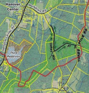 Driving Directions
- From Etna village, turn R onto Ruddsboro Road
- Follow Mink Brook as the road curves up its narrow valley for 1.5 miles
- Turn L onto Three Mile Road
- After 1.2 miles, arrive at the AT parking area on L opposite telephone pole 31-50 (if parking area is not plowed, park on shoulder)
- Today’s out-and-back hike, shown on the map at R, takes you to two fascinating historic sites.
What You Should Know
- In winter, we suggest hiking poles and micro-spikes or snowshoes for traction, especially for the brook crossings. If rising temperatures threaten to melt snow/ice cover on the AT, we strongly advise taking your hike in the morning while surfaces are still frozen, to protect the treadway. Corey Road can be wet if snow cover has melted, and boots are advised.
- You’re about to visit lands owned by the federal government (permanently protected) and a small portion of private land protected for AT corridor. Corey Road is a Class VI road open to the public subject to gates and bars.
- The Corey Road portion of this hike makes for great skiing. If you’d rather do that, enter Corey Road at its south end, at the junction of Three Mile, Old Dana, and Chandler Roads. Park with respect for the private residence at the historic cape here; walk up the driveway and through the gate to continue on the Class VI portion of this road.
- If you can’t bear to stop, you can combine this hike with a one-hour loop on the E side of Three Mile Road, posted as the February Hike of the Month: Mink Brook & the Harris Trail.
- Dogs are welcome if under your control; please pick up after your pet.
Brief Directions
- Take the AT westbound from Three Mile Road for about 15 minutes to Corey Road.
- Turn R and follow Corey Road for about 20 minutes to an historic stone bridge.
- Return the way you came.
Full Hiking Directions
- Begin your hike at the wooden AT sign set back from Three Mile Road and proceed gently downhill through a young mixed forest of pine and northern hardwoods. Here and there, the gleaming bark of yellow birch catches the sun.
- The 1855 and 1892 maps show no homes on this side of Three Mile Road between Chandler and the Wolfeboro Road, and so it was likely that most of this land served as sheep pasture then.
-
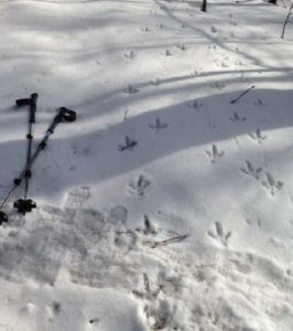
We missed the turkey parade! If snow conditions are right, you can mark the passage of many creatures in these woods. Red squirrels, deer, and turkey are the most obvious.
- Begin your hike at the wooden AT sign set back from Three Mile Rd and proceed gently downhill through a young mixed forest of pine and northern hardwoods. Here and there, the gleaming bark of yellow birch catches the sun.
- The 1855 and 1892 maps show no homes on this side of Three Mile Rd between Chandler and the Wolfeboro Rd, and so it was likely that most of this land served as sheep pasture then.
- If snow conditions are right, you can mark the passage of many creatures in these woods. Red squirrels, deer, and turkey are the most obvious.
- 8 minutes’ walk from your car, you encounter the remains of an ancient tree that split like a giant lily at its base. Three large trunks fell at R, and another to the L was cleared away.
- 5 minutes further, some kind soul has placed rough planks to help you cross a series of small rivulets. Send silent thanks to the dedicated trail maintainer of this section of the AT (we know who he is!) for keeping your feet dry.
- The largest of these brooks marks a transition to larger pine, and you note five blowdowns at L. Their fallen boles all lie SW of their tipped up root systems, hinting that a nor’easter took them down. As the years pass their root masses will decay, leaving only the mounds and pits we find all over New England forests that speak softly but eloquently of such forest disturbances.
-
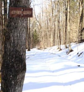
Corey Road Soon you reach a stone wall lined with large sugar maples, signaling your arrival at Corey Road. A close look at L reveals strands of barbed wire caught in the wood of one old tree, still on duty to keep the cows out of traffic.
- From the center of the road, turn completely around to note two wooden signs placed (thank you, Hanover Trails Committee volunteers!) to identify the historic road. You’ll want to keep an eye out for them on your return trip.
- Corey Road was laid out and surveyed on November 14, 1793 from the Wolfeboro Rd S to Chandler Rd, and was once an important link between Hanover Center and Enfield. One house stood on the road in 1855, but it was gone by 1892. By 1948, Corey Road was in disuse and Town Meeting voted to discontinue it subject to gates and bars. The AT was busier – Dr. Goldthwait noted a crossing of “the D.O.C. trail to Moose Mountain” when mapping the area in 1926.
- Turn R and head N down Corey Rd. Stone walls line both sides. As you proceed, some sections of the R wall are composed of much smaller stones than elsewhere, hinting that the ground nearby may once have been tilled. This more intensive use would have motivated the landowner to remove smaller stones that could damage a plow, and dispose of them in the wall.
- 6 minutes from the AT junction, you’ll head down a short, steeper pitch toward a brook – the same one you crossed on the AT. A formidable stone foundation appears at L on the other side. Stone walls and barbed wire mark boundaries.
- Cross this small brook carefully. The size of woody debris caught just below indicates that this brook can punch above its apparent weight during a heavy rain.
-
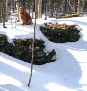
Corey-Woodard cellar hole Hike back up a few yards beyond the brook and past the stone foundation. Just as you reach more level ground, step off the road to discover a cellar hole, about 20 paces to the L. Likely the original Corey homestead, it was the home of one O. Woodard by 1855. The cellar hole is lined by a drylaid stone foundation. If it seems too small, consider that a cellar was needed under only a part of the home, and a glance to the N reveals a flat rectangular area where the rest of the house stood. Sited just above the road with SW exposure for solar gain and a good water source close by, this must have been a fine place to live. What happened to prompt its abandonment by the 1890s? We don’t know.
- After exploring the cellar hole, return to Corey Road and continue N. Here, the stone wall at R is composed of coarse boulders topped with barbed wire – the edge of a pasture, not a garden.
- 7 minutes after leaving the cellar hole, you arrive at a second brook crossing, this time forded with the most impressive surviving drylaid stone culvert in Hanover. Walk down to
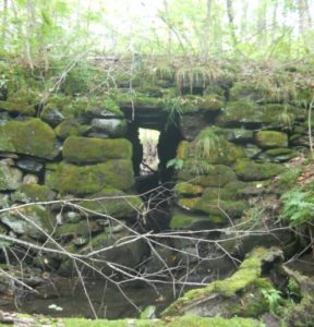
Corey Road stone culvert (fall 2012) the L on the S side to get a good view up to the moss-covered structure that has lasted here for 225 years. A close look reveals a flat stone lintel that carries Corey Road across the brook. The opening is tall enough to accommodate a short person. Imagine what it took to build this crossing! Even more incredibly, the home-grown engineering created a stable bridge that has withstood not only the centuries but also – so far – the sudden, higher flows from microbursts and other heavy storms associated with climate change.
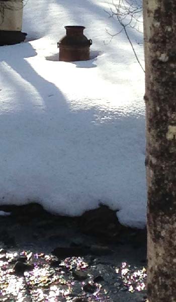
- Bright sky appears across the brook and above to the L, indicating an open field. Below the slope and along the streambank is a collection of what can politely be called “cultural debris,” such as an old milk can. It was once common practice to toss unwanted items over a bank, often near a stream. This spot is a little open air museum thanks to that habit!
- Like us, you’re probably tempted to linger by the bridge a bit longer, so we’ll tell you about the stream. This is Monahan Brook, the principal N tributary of Mink Brook. It rises N of Wolfeboro Road and flows SW to the Third Reservoir near Hanover Center Rd. From there, much of the water is diverted from Mink Brook and piped under the road and into the woods above the Parker Reservoir in the Trescott Water Supply Lands. Then it’s a short trip to downtown kitchens and drinking fountains. You’ve been hiking through more drinking water supply lands! However, the watershed of the Third Reservoir is only minimally protected – the Town owns only a narrow strip within 175-200 yards of the water’s edge. Federal land and AT easements protect a bit more, as do two privately conserved parcels at Monahan Brook’s headwaters, but otherwise this watershed is protected only by the good will of private landowners.
- Monahan Brook and the rest of the Mink Brook watershed were part of a statewide study by Trout Unlimited and NH Fish and Game biologists in 2011, assisted by the Hanover Conservancy. They found that “Hanover’s little Mink Brook and its tributaries showed a surprisingly healthy population of native Eastern Brook Trout.” You are now standing at one of those study sites.
- Corey Rd continues as a Class VI Road up to Wolfeboro Rd, but today we’ll retrace our steps and head S.
- 9 minutes’ walk brings you back to the first brook, where several channels join upstream of your crossing. Make a note of the time.
- Step over the brook and continue a gentle but steady uphill walk for about 8 minutes. Even under the snow, you can see the depression of the old road bed even though it has not been traveled for at least 70 years. Keep an eye out for the Corey Road sign at the AT crossing.
- Reach the AT and stop to listen to the sighing pines overhead, imagining the open sunny pastures that once flanked the road on both sides, shaded only by the old maples lining the stone walls.
- Turn L onto the AT and head E toward Three Mile Rd (and ultimately, N to Maine!).
- 15 minutes’ hike on the gently rising trail will bring you back to your car.
- A reminder – if you can’t bear to stop, you can combine this hike with a one-hour loop on the E side of Three Mile Road, the February Hike of the Month: Mink Brook and the Harris Trail.
March 2018, revised July 2020


