A loop hike on the Hudson Farm trail and the Appalachian Trail.
Difficulty: Easy
Distance: 1.75 miles round trip
Elevation gain: 150 feet
Time: 1 hour
Distance: 1.75 miles round trip
Elevation gain: 150 feet
Time: 1 hour
Categories: Hike of the Month, Hudson Farm, January
Tags: Appalachian Trail, bobolink
Hudson Farm Trail Guide in PDF form
 Driving Directions
- From Etna, take Trescott Road north for 0.5 miles to the junction with Partridge Road.
Park in the new parking area on the L side of the road (if it is plowed) at the blue sign reading “Old Highway 38 Trail.” - If the parking area is not accessible, continue up Trescott Road for another 0.4 miles to the AT parking lot on the R, just before a fence at the Trescott Water Supply Lands boundary. Your hike will end just across the road. To begin your hike, walk down Trescott Road to the new parking area at Old Highway 38.
- Today’s hike is a loop through the Hudson Farm’s fields and forest on an historic highway and the famed Appalachian Trail, highlighted on the map at R.
What You Should Know
- You’re about to visit one of Hanover’s newest conservation properties! The National Park Service has purchased the Hudson Farm, owned for many years by Dartmouth College, to permanently protect it as part of the Appalachian Trail corridor. The conservation project is a partnership between the Trust for Public Land, Hanover Conservancy, and Town of Hanover, celebrated in June, 2017. In addition to major federal funding, many local contributions made the farm’s protection possible. Over the years, the property was eyed as a site for everything from a housing development to a cemetery and golf course. We like it just the way the bobolinks and deer do.
 The Appalachian Trail Conservancy manages care of the land. Trails on the property are maintained by Berrill Farm neighbors and Hanover Trails Committee volunteers. The beautiful meadows will be kept open for their spectacular views and grassland bird habitat.
- Dogs are welcome but must be under your control; please pick up after your pet.
- Snowmobiles, ATVs, and bicycles are not permitted.
- In spring, wet areas make parts of this route difficult. Hunting is allowed in season.
Brief Hiking Directions
- Follow the Old Highway 38 Trail up along the edge of the field for 0.2 mi.
- Turn L at brown & yellow “Old Highway 38 Trail” sign for a brief detour to the nearby meadow for views.
- Return to the sign in the first meadow and walk straight, down the hill and enter the woods.
- Continue over boardwalks and through the woods to a junction with sign on L. Continue straight.
- At the next junction, bear R; trail is now blazed blue.
- Travel 0.2 mile and watch for pink flagging on trees and AT crossing (easy to miss).
- Take sharp R onto AT; note white blaze on tree on R. If you reach a playground you’ve gone too far.
- Follow AT & white blazes 12 minutes to Trescott Road. Turn R. Note orange sign at L at road.
- Continue 0.4mi back to start. Parking area will be at R at the base of the hill.
Full Hiking Directions
- Begin your hike where the Old Highway 38 Trail meets Trescott Road. The Town of Hanover constructed a parking area here, opposite Partridge Road.
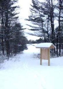
- Take the path beyond the trailhead kiosk to an open field, keeping the tree line on your left. Winter is a good time to visit this expansive rolling field, which is alive with nesting bobolinks in spring and summer (when your dog should be on a leash, at least here).
- Continue up the rise along the tree line that marks an old stone wall. You are walking through one of rural Hanover’s iconic historical farm landscapes.
- Seven minutes’ walk up from the trailhead, you’ll reach the far corner of the field. Here you’ll notice a brown and yellow trail sign where two paths meet, directing you to the right. Instead, turn L for a brief detour through an opening in the stone wall to a second, equally beautiful meadow.
- Stop for a moment to enjoy the expansive view. Straight ahead, the open hillside of Storrs Hill in Lebanon stands out, especially when covered in snow. At R are Rix Ledges, some of the most interesting terrain and wildlife habitat in Lebanon.
- Approach the small group of trees in the field, 30 paces away. From this vantage point you can see Mount Ascutney rising in the distance, to the right of Rix Ledges.
- RETURN to the first field and its brown and yellow trail sign. From here, you have a good view of the Adams Farm house, a late 18th/early 19th century white cape with a single chimney. This was likely home to the family that once owned the abandoned farmland you are exploring today. To the R, amid a clump of trees, is a 20th century home built by later owners. Archer Hudson, a retired architect, constructed the house as a country retreat and burned down the Adams Farm’s barn–the foundation of which remains. Dartmouth College later purchased the property and carved off the house for resale, keeping the land. While the College has long referred to it as the “Hudson Farm,” this is historically inaccurate as the property ceased to be a farm before the Hudsons acquired it.
- From the trail sign, with your back to the second meadow, follow the arrow on the sign and walk straight (turning R would return you to your car) to follow the tree line down to the lowest point in the rolling field. Here the yellow-blazed Old Highway 38 Trail enters the woods. A bog bridge offers an easy way across a small wetland. On this hike you’ll encounter some huge, open-grown “pasture pines” – white pines that grew up on abandoned agricultural land, with many lower branches. Some of them are monsters!
- Town Highway 38 has a murky history. Laid out in 1795, it originally led from Greensboro Road through this land to Trescott Road. In time it became a Class VI highway, but its exact route was so hard to trace that when planning began for the Berrill Farms neighborhood, the town agreed with the developer in 1979 on a route to be called the “Old Highway 38 Trail.”
- Soon you’ll ford another drainage on a crossing built in 2018 by Hanover Trails Committee volunteers. Protecting such headwater wetlands and streams from the erosion and runoff that comes with development is another reason to conserve this land – and will ultimately benefit water quality and trout habitat in Mink Brook from Etna to the Connecticut River.
- Rising back to dry ground, you’ll encounter not one but two stone walls on the R, another reminder that this land was once open pasture. The second wall forms a corner as you approach and follows you for a distance. Fresh yellow blazes mark your path.
- Soon, a sign at L indicates a turn in the Old Highway 38 Trail, where it will reach Greensboro Road in 0.9 miles. Instead, you continue straight toward the AT, 0.3 miles ahead.
- As you continue, an open area is visible downhill at R; this is the forested wetland that is the source of the small drainage you crossed earlier.
- 25 minutes’ walk from the trailhead, you reach another junction. The trail coming in at L originates at B
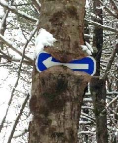
 errill Farms. Above to the L, a tree seems to be gnawing on a blue arrow. Ahead at R, another tree has made less progress consuming its arrow sign. Bear R here and follow the arrow and blue-blazed trail downhill past a large old wolf pine at R.
 - You’ll soon reach the yellow-blazed boundary of the original federal land embracing the Appalachian Trail corridor, before the corridor was expanded with the addition of the Hudson Farm. If there’s no snow cover today, you’ll notice the stone wall forming the old property boundary and the AT boundary pin next to the trail. Continue on the blue-blazed trail. Watch for ice underfoot as you cross a small drainage.
- Keep an eye out for bits of “cultural debris” such as a sap bucket. This is a good time to note that hunting is permitted on the AT and federal land surrounding it, so it’s wise to wear orange if you’re out between Sept. 15 and Dec. 15.
- A few minutes after passing the sap bucket, the famed Appalachian Trail crosses your path. While it is well marked with fresh white blazes, it can be easy to miss as the old trail continues straight. Turn R onto the AT and head for Mt. Katahdin (or maybe just your car). This is your second historic trail of the day. Benton MacKaye conceived of the regional trail in 1921, and after overcoming many obstacles including the 1938 Hurricane, World War II’s drain on trail maintainers, and the kind of political intransigence that is all too familiar, his vision became the National Scenic Appalachian Trail in 1968.
- Hemlocks shelter the trail here; if weather conditions are right, it’s easy to see how their stiff needles and short branchlets capture and hold snow before it can fall to the ground. Deer and other wildlife take advantage of the shallower snow depths under hemlocks, where it’s easier to move around. Wildlife managers call such hemlock groves “deer yards” for this reason.
- Soon you leave the hemlocks behind as the AT heads up a gentle knoll dominated by northern hardwoods. Continuing back down the north side, the trail enters evergreen forest again.
- About 8 minutes after turning onto the AT, you’ll encounter another wetland. The log crossing may be buried in snow – watch your footing. In summer, this place begets very dirty dogs.

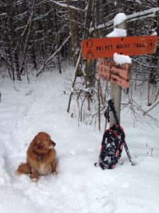
- Four minutes later you’ll reach Trescott Road and the Dartmouth Outing Club’s orange sign for the Velvet Rocks Trail. The AT parking lot is visible to the L across the road.
- If you left your car here, it’s time to end your hike. If not, turn R on Trescott Road and walk the 0.4 miles back down toward Etna and your car.
updated 9/1/2020


