An easy hike along the base of Moose Mountain.
Difficulty: Easy
Distance: 1.3 mile loop
Elevation gain: 140 feet
Time: 1 hour
Distance: 1.3 mile loop
Elevation gain: 140 feet
Time: 1 hour
Categories: February, Hike of the Month, Moose Mountain, Shumway Forest
Tags: Appalachian Trail, trout
Harris Trail Loop full PDF
 Driving directions
- From Etna village, turn R onto Ruddsboro Road
- Follow Mink Brook as the road curves up its narrow valley for 1.5 miles
- Turn L onto Three Mile Road
- After 1.4 miles, arrive at a big dip in the road with space for parking on both sides. (The AT parking area just S of it is not plowed in winter).
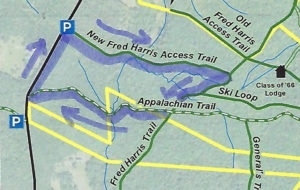
- Today’s hike, shown on the map at R, takes you on a loop that crosses Mink Brook twice.
What you should know
- In winter, we suggest hiking poles and micro-spikes or snowshoes for traction, especially for the brook crossings. The first part of this hike and the Harris Trail offer fine skiing, but the last part of the loop, on the AT, is narrow and often too steep for all but the bravest skiers.
- You’re about to visit lands owned by the federal government (permanently protected) and Dartmouth College (partially protected for AT corridor). The route also crosses a small portion of the Shumway Forest, protected in 2017 by the Hanover Conservancy (outlined in yellow above).
- Dogs are welcome if under your control; please pick up after your pet.
Brief Hiking Directions
- Begin at the orange Dartmouth Outing Club sign that reads “Parking/No Camping”
- Follow the gentle trail 7 minutes to the first crossing of Mink Brook
- Cross the brook and continue another 3 minutes to the Harris Trail
- Turn R on the Harris Trail
- Cross a stream (no bridge)
- Turn R on the Appalachian Trail and hike 10 minutes to second crossing of Mink Brook
- Continue on the AT for 6 minutes to Three Mile Road.
- Turn R and walk 0.2 miles along the road to your car.
Full Hiking Directions
- Begin your hike at the orange Dartmouth Outing Club sign that reads, “Parking/No Camping.”
- Known as the New Fred Harris Cabin Access Trail, this blue-blazed, half-mile-long trail was built by the Dartmouth Outing Club as a direct route to the college’s Class of ’66 Lodge (built on the site of the Fred Harris Cabin). We won’t visit the Lodge today, but you’ll find it on the map above.
- The trail is easy and rises gently to a plateau, passing through a long-abandoned sheep pasture. Here, small saplings are creeping into the understory sheltered by towering pines above. Years ago, all these lands between the road and the mountain ridge were owned by Luther Brown.
- Here and there, last year’s fragile leaves seem to shiver on beech trees. It’s believed that beeches evolved in the south and migrated to this area in the wake of the glacier, but never quite got the hang of dropping their leaves in fall like their northern brethren, the maples and birches. Admire the delicacy of their slender, cigar-shaped leaf buds.
- Seven minutes’ walk from your car, the appearance of a rivulet and its small steep valley at R signals the approach to Mink Brook. At L, a rough stone wall marks the plateau’s edge and the boundary of the old pasture.
- The trail takes you down a short, moderately steep section to a fine bridge installed a few years ago over Mink Brook. Look L upstream; the brook drains a rich and complex beaver-influenced wetland just out of sight on the Shumway Forest. Downstream, the brook may be covered in ice but still can be heard murmuring beneath. At R a small brook joins. You’ll cross this one soon; it is the same stream that pools near the Class of ’66 Lodge.
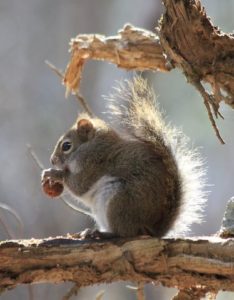
 The trail continues gently back up to a matching plateau on the east side. Deer trails cross and you may find leftovers from a red squirrel’s dinner in a pile of pine cone scales or acorn tops. The forest is different here – less pine, more hardwood – belying a different history. Could this have been Luther’s woodlot?
- Ten minutes from your car, you reach the Harris Trail, but if there’s been a recent snowfall, it’s easy to miss the junction. An orange DOC sign hangs on a red oak at R, facing the other direction. The sign reads, “To AT” and “To 3 Mile Rd & Parking,” indicating the path you just took. Across the intersection is a wooden sign reading, “<- Harris Trail ->” installed by energetic volunteers of the Hanover Conservation Commission’s Trails Committee.
- The Fred Harris Trail, former route of the Appalachian Trail, honors the Dartmouth Outing Club’s founder (1909). It offers wonderful skiing when conditions are right. The trail once ran from Moose Mountain Lodge Road N into Lyme, but a section N of Ferson Road can no longer be traced. The AT was re-routed off this path onto the ridge of Moose Mountain in the 1980s.
- Turn R onto the wide Harris Trail and head down to meet the brook you saw earlier. Alas, there is no bridge here, but with care and help from your hiking poles you can cross on the ice. Slow-growing hemlocks and yellow birch shelter the stream and hold its banks in place. At L, beyond the brook, a yellow blaze and white boundary sign signal the edge of the federal easement over Dartmouth land that protects the Appalachian Trail.
- The Harris Trail continues on its gentle grade. In a few minutes, an unmarked trail joins from L. Some maps identify it as the “Ski Loop,” a difficult ski trail built well before the AT.
- Bear R here as the Harris Trail continues its easy path downhill. Step over another rivulet.
- From this direction, especially in winter, you might not notice the Appalachian Trail crossing unless you’re alert for a rusted metal gate standing open across the Harris Trail. At L, the famous white blaze of the AT stands out on the trunk of a fine white pine about 40 yards uphill. At R, another orange DOC sign is posted on the far side of a white birch. 20 yards ahead a wooden sign reads “Old Harris Cabin Access Road.” If you continued straight on this for 1.25 miles, you’d come to a pull-off on Moose Mountain Lodge Road.
- Instead, turn R onto the AT to head W toward Three Mile Road (and ultimately, S to Georgia!).
- A few paces from the Harris Trail, you get an intimate view of the underside of a large fallen tree, up close and personal! Rising and falling are all part of a tree’s life cycle, and soon the trunk will become a nursery for its successors. The root mass will slowly melt into a mound, one of many sprinkled across New England forests.
- Eight minutes from the Harris/AT junction, the trail abruptly heads downhill across an arm of the Shumway Forest. This area was protected in 1983 with narrow easements embracing the newly re-routed trail. In 2017, the Hanover Conservancy strengthened this protection with a new easement over the entire 313-acre parcel that stretches nearly to the mountain ridge behind you.
- The trail displays a distinctly different character from those you’ve walked earlier today – it’s narrower with more twists and turns. It soon turns R then sharply L as it attains the spine of a narrow little ridge adorned with hemlock. Small branch tips and tiny cone scales on the snow at your feet reflect the foraging of porcupines and squirrels. Listen for Mink Brook before you see it.
- Head down a short steep section to enjoy the brook and a swig of hot tea from your thermos. Look around this tiny but dramatic little valley. Thick hemlock forest protects the watery home of wild brook trout, keeping waters shaded, cold, and full of oxygen in summer, just the way our native trout like it.

- These waters and the rest of the Mink Brook watershed were part of a statewide study by Trout Unlimited and NH Fish and Game biologists in 2011. They found that “Hanover’s little Mink Brook and its tributaries showed a surprisingly healthy population of native Eastern Brook Trout. In 16 survey sites, 213 Eastern Brook Trout were counted. The survey data also underline how important cold, clean water is for this species. Almost 70% of all the Eastern Brook Trout were found in five survey sites (some tiny upland tributaries) that had an average water temperature of 59.8 degrees.” You are now standing at one of those sites. If you have such a stream on your property, what can you do to help brook trout? Keep a lush buffer of trees and shrubs to shield the water from the summer sun.
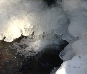
- In winter trout are tucked away, but you can enjoy the glittering play of water against ice and snow, all the more glamorous on a bright day.
- Cross the two-log wood bridge, sending a silent thanks to the person who added the handrail. Head up a short slope, leaving Mink Brook to continue on its way to the Connecticut.
- Here, the AT moves fitfully across 21 acres purchased by the federal government from none other than the Mascoma Beagle Association. We’d really like to know the story behind that.
- Six minutes from the bridge, you arrive at Three Mile Road. Turn R and head back along the road 0.2 miles to your car, soon within view in the dip below.
- Be sure to come back in the spring, when Mink Brook will have even more to say!
February 2018, revised July 2020


