A gentle hike into history, close to Etna.
Distance: 2.0 miles round trip
Elevation gain: 80 feet
Time: 1 hour
Categories: Hike of the Month, September, Trescott
Tags: cellar hole
Route Description and Map – Full PDF
 Driving Directions
- From Downtown Hanover and the Green, drive E on East Wheelock Street and up the hill 1.7 miles to the junction of E. Wheelock, Grasse, and Trescott Roads. Bear R to continue on Trescott Road and drive 1.2 more miles to the Trescott gate at a sharp bend.
- From Etna village, turn W onto Trescott Road and drive 1.3 miles to the Trescott gate at a sharp bend.
- Park at the marked trailhead parking area near the kiosk. Please do not block the gate.
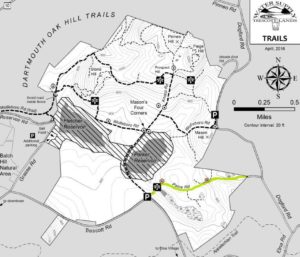
- Today’s hike is highlighted in green on the map at R, with cellar holes indicated in brown.
What You Should Know
- Welcome to your water source! Drinking water for much of Hanover and Dartmouth College comes from these lands, so special rules apply for recreational use.
- Take a moment to check the kiosk display to acquaint yourself with these rules and pick up a trail guide. Note dates for various deer hunting seasons. Deer hunting is encouraged here to improve the forest, and it is wise to wear blaze orange Sept. 15-Dec. 15.
- Dogs are welcome but must be leashed at all times; please pick up after your pet. In fall, many hitch-hiking plants would love to send their seeds home with your dog. After picking many small burrs off a golden retriever (on a short leash for the entire trip) we wished we had left her at home.
- You may encounter forestry vehicles; they have the right of way.
- Most current hiking routes in the Trescott lands make use of historic roads, including this one.
Hiking Directions
 Take the short path to the R of the kiosk that leads around the fence. This takes you to Knapp Road. Turn R back toward the gate and after 25 yards, turn L onto Paine Road. For well over a century, this was a four-way intersection.
- The route now called Paine Road was laid out in 1782 from Jeremiah Trescott’s place to Dogford Road, “to accommodate him for Meeting.” He’d been asking for an easier route from his house to Hanover Center since 1775. Who Paine was and why the road now bears that name remain a mystery.
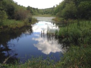
- Paine Road leads invitingly down a gentle hill for several minutes’ walk. Approach the dip in the old road softly; if you’re lucky, you’ll get a glimpse of a great blue heron or other wildlife in the beautiful flowage on the R.
- This valley is not as small as it first appears – it extends well over a half mile; off to the L, it feeds an arm of Parker Reservoir. The wetland captures sediment washing off higher ground before it can enter the drinking water reservoir, where clear water is an important concern.
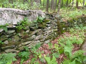
- The old road continues up out of the hollow. Just as it swings R, stop and look for the remains of an old stone wall at L. You have found the site of the Wright-Mason Farm.
-

Cellar hole of the Wright-Mason farm To find the farmhouse’s cellar hole, follow the line of this wall into the woods with your eyes to a pile of large, flat stones, about 35 paces from the road. Leave the road and walk to this point and then continue straight, another 25 paces, to a small grassy rise. The cellar hole will be invisible until you’re nearly upon it, so keep a sharp lookout!
- Here is what seems like a very small house foundation, with ash trees growing in and around it. One has made such close friends with a foundation stone that it appears the stone is growing into the tree instead of the other way around.
- Was this really such a tiny house? Actually, most 18th and early 19th century homes had cellars under only a portion of the house, as cellars were not easy to dig and were needed just for storage of apples and other foodstuffs, not for the many purposes to which we put basements today. On the N side of the cellar hole you may discern other foundations, perhaps indicating a house with an ell. More research is needed.
- In 1855, one H. Wright occupied this farm. Little is known about this family. By 1885, Charles J. Mason, Jr. owned it. He grew up at Mason’s Four Corners and his family owned much land in the neighborhood. This house and other farm buildings were removed when the Parker Reservoir was built.
- Return to the road and continue E (away from the wetland).
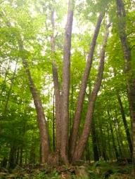
 You begin to notice old sugar maples lining the road, and ahead on the L at the top of a rise is an impressive “fairy ring” of trees. Five large ash trees seem to spring from a single place. Look closely and you’ll see the cut stump of a sixth. All of these are sprouts from the stump of a single earlier ash. What’s the story? Did Mason cut the parent ash for firewood and leave his farm before he could come back for the sprouts once they grew to size?
- Continue your walk along Paine Road, which now levels out. A nice low stone wall follows on the L, and handsome sugar maples 20” in diameter line the lane. They were probably set out along the road by the Wrights and their mid-19th century neighbors, the Johnsons, when the rest of the surrounding land was open pasture or cropland. Now, the forest has returned but the maples still reign.
- A close look at some of these walls reveals small stones among larger ones, indicating that the land nearby was cultivated and therefore it was worth the trouble of moving rocks of that size.
- Pass a small pocket of red pine plantation on the R; it looks oddly out of place here in the hemlock-white pine-northern hardwoods forest that surrounds it. The plantation is a leftover from earlier watershed management efforts. Nowadays, the foresters tending the Trescott Water Supply Lands are guiding the woods back to a more natural, uneven-aged, multi-species forest like that surrounding this plantation.
- As you walk along, the stone walls grow more prominent and you have the odd but peaceful feeling that they’re keeping you company.
- Twenty minutes from your car, you arrive at a log landing – a sunny opening with small piles of cut logs hidden in the growth at its edges. Timber pulled through the woods is delivered here by a skidder and cut to length before transfer to a lumber truck. When not humming with logging equipment, a landing like this can be busy with wildlife enjoying the opening in the forest and the berry bushes that often grow on its edges.
- Just past the log landing is a big white pine snag that turns out to be one of four. These big “wolf pines” may have been left behind because their uneven form diminished their value as cut lumber. The wildlife doesn’t mind, and the old pines make great apartment dwellings for woodpeckers and other creatures.
- As you continue on Paine Road, stone walls seem to be everywhere, following the road and heading off into the woods at right angles, separating fields and pastures of another time. They were likely built by A.D. Johnson, whose home site you will soon visit, during the “Sheep Craze” of the early-mid 1800s.
- As you head up a small rise, a woods road comes in from the L. Continue straight.
- Walk over a pronounced lump in the road – this is a water bar, built by the foresters to keep water from running down the road and creating gullies. Good forest management in a public water supply watershed is all about managing water!
- About five minutes’ walk past the log landing, you’ll reach a flat spot on the L, site of the Johnson-Camp Farm. This cellar hole is easily visible from Paine Road, just 18 paces away. While this one is nearly square, the farmhouse that stood over it was probably rectangular and extended to the W.
- The 1855 map of Hanover shows A. D. Johnson at this site. By 1885, Carlton N. Camp lived here, a descendant of the family that gave the Camp Brook watershed its name. The 1885 Grafton County Gazetteer records him farming 75 acres with a sugar orchard of 150 trees and leasing 40 more acres from a William Doten. Camp’s Civil War service was also noted: he served in Company B of the 18th NH Volunteers. What a nice view the Camps must have had in the days when this land was clear and abundantly decorated with their stone walls. We suspect he was glad to get back to his farm in New Hampshire when the war ended.
- After exploring the cellar hole, continue E on Paine Road. You’ll soon come to a sign and barbed wire marking an old water company property line; walk around the large pine on the R to pass through a gap in the fencing, taking care to avoid a brush with the wire.
- Paine Road heads gently downhill and, on a sunny day, a flush of light through the trees catches your attention. You’ve reached another wetland, which you recognize as the large swamp that is visible from Dogford Road. Cattails and other marsh plants grow amid the standing skeletons of dead white pines. A big wetland in a bowl like this helps hold heavy rains like a sponge, protecting people downstream in Etna from sudden flooding.
- Climbing up out of the bowl you soon reach the spot where Paine Road once again becomes a traveled way (restored to active use in 1971). Here, private land comes close to the road and is posted in some places. Please take care to respect these neighbors.
- Turn around and return W on Paine Road, retracing your steps. As you pass the Johnson-Camp Farm’s impressive stone walls, resolve to return when the leaves are off the trees for a better look.
- Linger a moment at the valley wetland before ascending to Trescott Road. It’s a beautiful and quiet spot, yet so close to a road busy with cars hurrying between Etna and downtown Hanover.
Learn more about the Trescott Water Supply Lands
 Thanks to the Hypertherm HOPE Foundation for support in creating this Hanover Hike of the Month.


