Trail Description and Map – Fu …
Difficulty: Easy
Distance: 1.1 miles round trip
Elevation gain: 250 feet
Time: 0.75 hours
Distance: 1.1 miles round trip
Elevation gain: 250 feet
Time: 0.75 hours
Categories: Hike of the Month, September, Slade Brook
Tags: Class VI Road, fisher, foamflower
Trail Description and Map – Full Hike
 Driving Directions
- From downtown, head N on Rt. 10 past Hanover Conservancy offices
- Continue on Route 10, 3.3 miles past the N rotary
- Turn R on Old Lyme Rd. and drive 0.2 miles to a sharp bend.
- Park on R on gravel shoulder.
What You Should Know
- Foot travel only, except for Old Spencer Road.
- Dogs are welcome but must be under close control.
- This loop hike passes through the Barnes Estate, owned and managed by Dartmouth Hitchcock Medical Center, before reaching the Huntington Hill Wildlife Management Area, a major privately owned parcel protected by a conservation easement held by the NH Fish and Game Department.
Hiking Directions
- There’s a secret waiting for you right here, before you start into the woods. Walk a few dozen yards back down Old Lyme Road to the guard rail marking Slade Brook’s passage below. Look carefully on the left beyond the far end of the rail for a dramatic drylaid stone bridge abutment. This once carried the original road linking Hanover to Lyme and points north. Today, we whiz by this area at 50+mph on a much straightened, widened, and otherwise altered route. Imagine journeying to Lyme on the poky narrow road that existed before Dartmouth urged the state to “improve” travel to its new Skiway in Lyme Center.
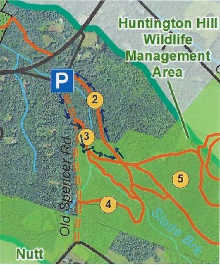
- Back at your car, look for two routes into the woods. At L, a woods road heads uphill, blocked with a cable. This is where you’ll return. At R, a clear, narrower level path leads in to the woods. Begin your hike here.
- In a few yards you’ll pass over a narrow wooden footbridge, built by volunteers shortly before the Hanover Conservancy protected the Jim and Evalyn Hornig Natural Area at Lower Slade Brook, just downstream from Route 10. (2007) This crossing replaces an earlier one – look down to the left to see remains of the old stone abutment for the bridge that once carried Old Spencer Road over this stream.
- Follow Old Spencer Road through the woods and up the hill to an upper river terrace that was once the shore of glacial Lake Hitchcock. This land is part of the former Barnes Estate, now owned by DHMC.
 Old Spencer Road links Old Lyme Road with Dogford Road, built in 1816 “from Benjamin Thatcher’s to the County Road.” Thatcher’s place (known today as the Nutt Farm on Dogford Road) was later owned by Captain Uel Spencer. Town Meeting voted to discontinue the road subject to gates and bars in Hanover is criss-crossed with dozens of early roads like this one, providing fine hiking, snowshoeing, horseback riding, biking, and skiing now that they are retired and no longer maintained for more intensive use.
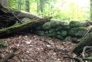
- About 7-8 minutes from the bridge, you’ll reach a tree down across the old road (which may be gone by the time you read this) and a junction. Old Spencer Road continues straight uphill. A logging skid trail is visible nearby at R. What appears to be another skid trail bears off Old Spencer Road at L. This is the Bridle Path, and your turn. Before taking it, continue another minute or two up the old road as it fully reveals its historic character. Partly buried stone walls mark each side and the roadbed appears sunken between them. Barbed wire follows the wall on the S side, a reminder that cattle once pastured here before the forest returned.
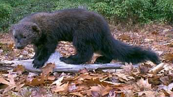
 Watch for wildlife – on the day we visited, a fisher paused here on the wall to observe us. The largest member of the weasel family, the fisher is a lithe and talented predator that makes a specialty of dining on porcupine.
- Return to the junction and take the Bridle Path that veers NE. It too has been used recently as a skid trail, but it quickly narrows and you’ll soon hear the music of Slade Brook at L.
- After five minutes’ walk from Old Spencer Road, a new wooden bridge comes into view as you cross onto the Huntington Hill Wildlife Management Area.
- Pause on the bridge to admire both the workmanship and the partnership that built it in May-July, 2017. A determined team of 20 volunteers, led by Hugh Mellert and the Hanover Conservation Commission’s Trails Committee, built the bridge with permission of the private landowners and help from the Upper Valley Trails Alliance, Hanover Public Works, Hanover Conservancy, Cardigan Mountain Highlanders, DHMC, neighbors, and hikers who happened by and jumped in. Funds for materials were donated and the 250 person hours of labor were free. This new bridge replaces one that’s been gone for 50 years, and provides a safe and valuable connection to the network of trails on Huntington Hill.
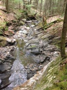
 Now turn your attention to the brook itself, and the fascinating variety of rocks composing its bed. Water-worn granite alternates with leaves of uplifted, slanted sedimentary rock that speak volumes about the deep geological history of this place.
- Two trails meet at the far end of the bridge. Bear L onto the wider of the two and head steadily uphill through a pine/hemlock forest. Faded pink flagging marks the route.
- About 10 minutes’ walk from the bridge, you reach the top of a rise where the Barnes Trail comes in at L by two large white pines. Just ahead, another trail junction is visible.
- Turn L onto the Barnes Trail and head down the narrower, pine needle- strewn path. The Barnes Trail is easy to follow as it meanders pleasantly down the slope. There’s a nice patch of foamflower (Tiarella cordifolia) on the R just before you cross a small drainage. Resolve to come back in May to see this native wildflower in bloom. The Barnes Trail begins to feel like an old woods road.
- Cross another, larger drainage. Ten minutes’ walk from the last junction, reach a sunny opening filled with native wildflowers like Queen Anne’s Lace and various kinds of goldenrods, but with an ominous patch of Japanese knotweed. This log landing provides a valuable bit of open habitat nevertheless.
- Continue across the clearing and re-enter the woods.
- The trail, now an obvious logging road, passes through another small opening and then swings L and heads down to where your car awaits.
Please respect the generosity of these landowners by leaving no trace of your visit and enjoy the memories and photographs you take home.
8/30/2017


