An easy loop in the Mink Brook Nature Preserve close to downtown
Distance: 1.75
Elevation gain: 30
Time: 0.8
Categories: Conservation, History, March, Mink Brook, Trails
Tags:
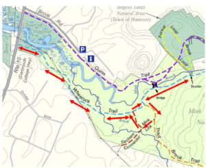 DOWNLOAD FULL PDF-Mink Brook South Side Storied Stones
Driving directions:
- From downtown Hanover, drive south on Main Street (Route 10) 0.5 miles
- Cross the bridge over Mink Brook
- Turn R into Pine Grove Cemetery and park.
- Walk across Route 10 to begin your hike.
What you should know:
- Dogs are welcome but must be under close control (better yet, leashed); please pick up after your pet.
- Foot travel only. Bicycles are not permitted in the Mink Brook Nature Preserve.
- Trail maps are posted at trail junctions and are available at the trailhead kiosk near the Brook Road gate.
- The Preserve is home to bears who may emerge from hibernation as early as March (another reason to leash your dog). If you encounter a bear, do not run but speak softly to it and move away slowly. Mother bears are as protective of their young as we are.
- After crossing a small town-owned space next to Route 10, you will visit the 112-acre Mink Brook Nature Preserve, owned and managed by the Hanover Conservancy since 1999.
BRIEF HIKING DIRECTIONS
- Take the Wheelock Trail along the S side of Mink Brook.
- Continue past the old log crossing to a group of large boulders.
- Return past the log crossing on the Wheelock Trail.
- After the Wheelock Trail turns L, bear L onto the Trout Brook Trail.
- Bear R onto the Mink Link across a set of bog bridges.
- The Mink Link meets the Sachem Connector at Trout Brook.
- Turn R onto the Sachem Connector and L onto the Wheelock Trail.
- Stay on the Wheelock Trail to return to your car.
FULL DIRECTIONS
- Begin your hike by walking through the open area toward a telephone pole visible ahead on the easy, flat Wheelock Trail, named for Dartmouth’s founder. This land and a mill privilege just upstream on Mink Brook were offered to Eleazar Wheelock as an incentive to locate his new college in Hanover.
- You’ll soon encounter a Hanover Conservancy sign as the trail heads into the woods. A smaller sign reminds that bicycles are not permitted on the Preserve, a condition of the generous gifts that made purchase of the land possible.
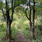 The trail enters the woods and 5 minutes from the road, passes through a natural gate of two impressively large (for them) musclewood trees (R). A look at their limbs hints at the reason for this odd name – they look like they’ve been to the gym!
- The blue-blazed trail passes briefly under a power line and then through a richly mixed hardwood forest.
- 4 minutes from the musclewood gate, look for a large multi-stemmed cherry tree at L. Bear L at a Y here, where a private trail enters at R. The Wheelock Trail traverses Mink Brook’s flat floodplain.
- 2 minutes later, a pair of logs takes you across Trout Brook. This stream rises in Lebanon and flows north to meet Mink Brook. It might not look like much here, but in its upper reaches on the Preserve it provides very high quality habitat for (albeit small) wild brook trout, here almost within sight of downtown Hanover.
- 4 minutes later, the trail rises to a junction with the Sachem Connector, a red-blazed trail at R. You’ll return on that path. For now, stay L among the big pines.
- You’ll soon cross a small drainage on a series of stepping stones. Just beyond is the junction of the orange-blazed Trout Brook Trail. You bear L to stay on the blue-blazed Wheelock Trail.
- A few steps further, at a big double pine, the Wheelock Trail turns R. A spur trail at L leads to stepping stones across Mink Brook to the N side of the Preserve. This is where a bridge was planned to serve a proposed 32-lot residential subdivision in the area you’ve been exploring. Give a cheer for the 500 donors, the Quinn Family, and Dartmouth College for recognizing the natural value of this place and stepping up to help the Conservancy and Upper Valley Land Trust protect it. The Hanover Conservancy now owns and manages the land, with conservation deed restrictions from UVLT.
- Continue E on the Wheelock Trail for a few minutes to the former log crossing. Crafted in 2009 from a nearby tree, it served as a temporary trail link until the fall of 2021. A replacement crossing is planned. A sign on a tree opposite the log crossing directs you to continue E on the Wheelock Trail toward Buck Road. We’ll turn around well before that, but recommend that route for a summer’s day. Note an island in the brook on your L; until Tropical Storm Irene came through in 2011, Mink Brook flowed mostly between the path you’re on and this island. High water caused the brook to change course to the far side of the island, and this area is wet only a few times each year. Brooks are dynamic!
- Continue to follow the brook upstream through deepening hemlock and pine forest.
- 3 minutes’ walk from the log crossing, note a large, flat-faced stone ahead at R. Stop and look more closely – a jumble of large stones nearby appear to have been placed a very long time ago – but by whom?
- Watch your footing as the trail bears L among boulders, ledges, and roots, past an ambitious hemlock growing over a low stone wall.
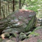 The most massive stone of all rears up at L. Follow the trail up a few yards to a nearby lookout above a small waterfall on Mink Brook. You have reached your destination.
- These silent stones clearly have stories to tell. We don’t know what the stones might say, but in our imaginations, they must be eloquent – they are the original and timeless inhabitants of this beautiful stream valley.
- Through the millennia Mink Brook, or Mosbasak Zibosiz in the Abenaki language, has been a key part of local Abenaki village and subsistence grounds. From the time of Dartmouth’s founding, Abenaki and other Native families lived in this area to support their children who were enrolled in Moor’s Charity School and the College. Abenaki families have lived nearby to this day. What is known today as the Mink Brook Nature Preserve has long been known as a “woman’s place,” and when Eleazar Wheelock arrived to raise his college, Abenaki grandmothers met with his people to lay out their expectations for how the land would be used.
- It’s hard to imagine this place as a residential subdivision and yourself standing amid driveways, garages, mailboxes, landscaped yards, and houses with dogs and cats. Turn your thoughts instead to the public-spirited vision of those who worked to protect this place so the stones could continue to speak to all.
- After visiting with the stream and the stones, retrace your steps past a glistening yellow birch and head W on the Wheelock Trail. Pass the old log crossing and bear L at the forked pine, leaving the brook behind.
- In a few paces, reach the junction with the orange-blazed Trout Brook Trail. Bear L here, following the little rivulet upstream.
- In 2 minutes’ walk, pass a big rock at R and arrive at another trail fork marked with a “no bikes” sign. Bear R onto the Mink Link. Cross the wetland here on a new bog bridge.
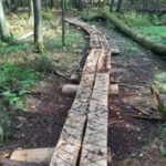
- This crossing and another you’ll soon encounter were built in 2019 by Andrew Chen of Troop 45 for his Eagle Scout Project. The task was to create a dry crossing of split and peeled hemlock logs through a wetland that had been trampled by hikers making an informal shortcut. With the bog bridge in place, the wetland has recovered well. An incredible 176 hours went into this project. The Hanover Lions Club and the Rankin family contributed to the cost of materials. Thanks to all!
- The Mink Link Trail moseys up and among the hemlocks and pines, soon reaching another of Andrew’s log crossings. Note a posted map at L marking the junction of the Mink Link and Sachem Connector. Hop up on the bridge, which crosses Trout Brook.
- Andrew’s bridge replaces another one that previously washed away in high water. Does the tame little stream you’re viewing today seem capable of such a feat? Had this land not been protected and the area altered with construction of roofs, driveways, and other surfaces that would prevent rain from soaking into the ground, this brook could have become downright dangerous during the heavy storms now associated with climate change. Now, a thick forest canopy and a blanket of natural duff over the soil act as a sponge to let the water flow more slowly and with less force when the hard rains come.
- Return to the trail sign and bear L to take the Sachem Connector Trail up and around a small knoll. The trail is blazed red, but you won’t see the next blaze until you’ve gone around the bend.
- 10 minutes from the Trout Brook Trail, you return to the Wheelock Trail amid some impressively tall pines. Bear L at a Y around two of them.
- You’ve just passed most of the way around one of many oddly steep ridges that mark the sides of ancient channels of Mink Brook. This region was once inundated by the frigid waters of glacial Lake Hitchcock, and the clay/silt lake-bottom sediments were easily sliced by the rushing waters of the brook after the lake receded, leaving steep-sided ravines.
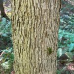 3 minutes later, cross Trout Brook again. Just a few yards beyond, note two large “basket ash” trees, one on either side of the trail. These are a species of ash with pale, finely flaked bark that are favored for the making of baskets by Native American craftspeople.
- Bear R at the many-stemmed cherry tree to avoid the neighborhood trail at L.
- 9 minutes from your last crossing of Trout Brook, arrive back at your car. Resolve to return as spring unfurls at Mink Brook. This is a great walk at any time of year.
Note: The Hanover Conservancy seeks volunteers to monitor trails and help out with occasional work parties. We also warmly welcome donations to our Mink Brook Stewardship Fund to help maintain the Preserve. Get in touch at info@hanoverconservancy.org. For more about the Mink Brook Nature Preserve, visit www.hanoverconservancy.org/lands/mink-brook/.
This Hanover Hike of the Month is generously sponsored by Snyder Donegan Real Estate Group
September, 2021


