An easy, mostly flat walk along a lovely stream. This is a good spring hike, when the falls are often at their best.
Distance: 1.0 miles round trip
Elevation gain: 200 feet
Time: 35 minutes
Categories: Hike of the Month, May, Slade Brook
Tags: Hornig, Louisiana waterthrush, horsetail
Slade Brook Hike – full PDF
 Driving Directions
- From downtown Hanover and the Green, follow Route 10 north for 4.2 miles to River Road and turn left.
- Follow River Road for 0.5 mile.
- Just past Purling Brooks Drive, cross Slade Brook near its confluence with the Connecticut River.
- Turn immediately right into the small parking area.
What You Should Know
- Foot travel only. Dogs are welcome but must be under close control; please pick up after your pet.
- The trail is not blazed but is easy to follow. Wooden arrows mark important turns.
Hiking Directions
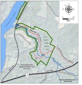
- Take a moment to check the kiosk display and map before embarking on the trail beyond the rocks.
- Slade Brook flows 4.0 miles from a wetland near Three Mile Road west to the Connecticut River, draining a largely forested 2.55 square mile watershed. Nearly a third of this watershed is permanently protected, including the 38-acre Lower Slade Brook Natural Area, Huntington Hill Wildlife Management Area, Moister Meadow, and several other parcels.
- At this time of year, the dark green of stiff-stemmed horsetail, or scouring rush, is prominent. Our forebears used this primitive native plant, its tissues naturally fortified with silica, to scrub dishes.
- The brook takes its name from Capt. Samuel Slade (1747-1826), described as a “leading citizen” of Hanover who came to town around 1774 and eventually served as tithing man, selectman, and representative. A Revolutionary War soldier, Slade was part of a committee to raise soldiers for the Continental Army and was stationed at Fort Ticonderoga. He, his wife Sarah, and their 13 children lived one mile north of Hanover Center (house later burned) and were prominent members of the Hanover Center church. His grandson, Samuel Thompson Slade (b. 1810) married a Huntington girl, so the family was clearly frequenting the neighborhood. Generations of Slades are buried at Hanover Center.
- Shortly after leaving your car, note a dramatic ravine on the left. This steep, narrow cut was carved out thousands of years ago by Slade Brook as it scoured through lake-bottom sediments left behind by glacial Lake Hitchcock.
 Listen as you walk for the Louisiana waterthrush. The male’s song is a musical, distinctive series of descending notes followed by a warble. One of the earlier neotropical migrants to return to its breeding grounds in the spring, this bird often arrives a month or more before other warblers. The hilly forest surrounding Slade Brook offers prime habitat for the waterthrush, as its name indicates.
- On a terrace above the brook, the trail follows a very gently rising path that may once have been an old tote road. Evergreen Christmas fern decorates the banks at left.
- As the trail bears to the right, the first flume comes into view and the trail heads up a short rise. A second flume appears above the first.
- The trail soon levels again and offers a view down onto the floodplain of the brook. The wet, mossy expanse hints at its important function of storing water during heavy rains and snowmelt.
- As you continue, the trail moves a short distance from the brook into a grove of hemlock, yellow birch, and white pine. Admire the birches’ glowing papery bark. Some, growing on the rotting remains of old fallen trees, are working on a giraffe imitation as their roots stretch down to the soil. The forest promises a cool retreat when you return on a hot summer day.
- About 12 minutes’ walk from your car, you catch the sound of water again, drawing you off the trail a few feet to the right to view the uppermost waterfall. Here, the brook takes two paths down mossy stepped ledges, and then sluices away to the southwest through a short, narrow gorge. The entire flow from the brook’s 1,630 acre watershed passes through this point.
- After admiring the falls, continue up the path.
- Just beyond the falls, stepping stones lead across the brook to a short (0.15 mile) side trail to the Purling Brooks neighborhood. The public is welcome to use this trail as far as the Natural Area boundary, but may not continue across private land.
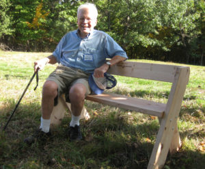
 That brings us to the story behind the Natural Area’s protection in 2005. When a developer presented a plan for 17 houses in this area, the Conservancy (then the Hanover Conservation Council) proposed an alternative that resulted in 10 homes clustered on 20 acres on the south side of the brook, on the site of a former gravel pit, with the rest of the property left intact. This solution protected the brook and its undisturbed valley, while providing recreational trails for homeowners in the Purling Brooks neighborhood and the wider community. Jim Hornig, former president of the Council, was the inspiring force behind this idea, and the Council gratefully named the Natural Area in honor of Jim (right) and his wife, Evalyn.
- Watch for the sharp left turn as the trail heads away from the brook and somewhat steeply up to a plateau. About 5 minutes past the falls, you’ll come to a remnant of barbed wire on the right, marked with flagging, a reminder of the grazing history of this area. This land was once part of the Piper Farm.
- The trail continues past the Conservancy boundary to a trail junction. To the right, an old logging road heads 0.25 miles to Route 10. To the left, it leads to private land.
- Turn around and head back toward Slade Brook, enjoying the chance to see what’s growing at the top of the steep knolls you saw earlier from below.
- Turn right at the arrow and head toward the waterfall. In the afternoon, the sun filters through the hemlocks, illuminating the falls. If you hear voices off to the left, it’s probably children playing near the houses across the brook. Consider how lucky they are to grow up with such a beautiful brook in their back yard, thanks to the foresight of those who protected it.
- Slade Brook follows you down to your car before it joins the Connecticut River on its journey to Long Island Sound, hundreds of miles away.
The Hanover Conservancy owns and manages the Jim and Evalyn Natural Area at Lower Slade Brook. The Upper Valley Land Trust holds a conservation easement on the land. To protect the south bank of Slade Brook, the Conservancy holds a conservation easement on parts of eight properties at Purling Brooks Drive.
Note: The Hanover Conservancy is seeking volunteers to advise us on managing the Natural Area, monitor trails, and help out with very occasional work parties. We also warmly welcome donations to our Land Stewardship Fund to help maintain the Natural Area. Learn more about the Lower Slade Brook Natural Area.


