


Baum Conservation Area – Full PDF
 Driving Directions
- From Etna Village, head N on Hanover Center Road
- Turn R on Ruddsboro Road and continue to end on Route 4
- Turn L on Route 4, drive 1.6 miles to Enfield Village
- Turn L onto Maple Street; bear L at junction with May Street.
- Drive 3.1 miles to the well-marked Baum Conservation Area entrance (1.7 mi. past Hanover-Enfield line).
What You Should Know
- This is a hike for confident hikers with good trail skills. The trails are not the well-beaten paths you find at Balch Hill or the Appalachian Trail, which is part of the adventure. Bring a compass.
- Some of the route follows grassy former skid trails; anticipate insect hitchhikers and do a tick check.
- Foot travel only. Dogs welcome if under close control. You’ll pass prime porcupine habitat – we know from experience.
- The route visits the Baum Conservation Area and the Dana Forest and Pasture Natural Area, parts of a 3,800-acre block of protected high-elevation wildlife habitat on Moose Mountain.
 Hiking Directions
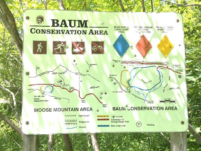
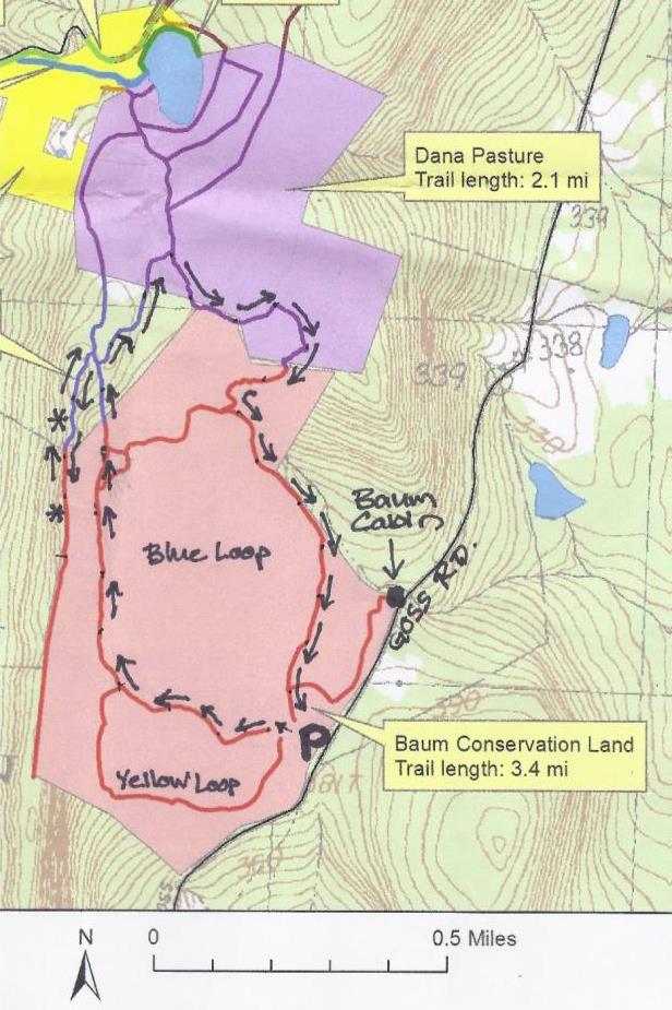
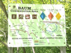
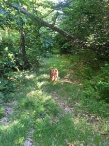
- Begin your hike at the large triangular flat rock at the SW edge of the dirt parking area, after familiarizing yourself with the trails depicted on the posted entrance sign. You’ll be touring most of the 1.6 mile Blue Loop today, with a couple of additions.
- To protect mountain wildlife habitat next to the Dana Forest and Pasture Natural Area and to offer public access to the trails you’ll be exploring, Dartmouth alumnus and outdoorsman Jim Baum and his wife Carol purchased this 239-acre area and gave the Town a conservation easement on the land. Jim worked with the Upper Valley Trails Alliance to improve the trails.
- Start up through the trackless meadow, aiming for a point at 10 o’clock on the surrounding tree line. Soon a bare bit of smooth ledge appears with a small cairn to reassure you. Look for a yellow diamond sign with an arrow at the edge of the woods. Here, you bear R (not L) onto a mowed path.
- An old skid trail turned hiking trail, the path soon begins to ascend gently but steadily, with mosses and herbaceous plants underfoot. Continue past a wide trail leading back down to the meadow. Shrubs such as a native honeysuckle and spiraea line the way. You can tell the soils here are moist, receiving subsurface water from upslope, as the path is carpeted with water-loving sedges. The curious fruiting body of the most common one looks like a pudgy green porcupine or blowfish. It looks prickly, but it’s not.
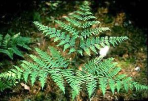 About 18 minutes from your car, the trail bears R and levels out. A blue arrow confirms you’re on the Blue Loop. Waist-high bracken fern grows exuberantly. If a deerfly has discovered you, thwart it by joining the Order of the Bracken – pick a frond and wear it upside down on top of your head! Deerflies are programmed to swarm around the highest point of their prey – and will hover at the top of the fern stem.
- 4 minutes from the blue diamond, look for yellow and blue diamonds on a tree at L. The trail swings L and moves through a thick young forest of pole-sized trees 1-3” in diameter. Grouse enjoy this habitat and you may suddenly flush one, startling both of you. Listen for the liquid notes of a wood thrush.
- Another 4 minutes’ walk brings you to a clearing where a yellow arrow points L. You bear straight toward an opening filled with sun-loving, fragrant, hay-scented fern. Foresters don’t like this fern (or bracken) because it tends to quickly colonize forest openings, shading out any tree regeneration they encourage.
- The trail moves gently up and curves L and R, ducking in and out of fern openings. As you ascend, now heading N, note the change in the woods. Here, older yellow birch and beech dominate the bony land. A few dips in the trail remind you that it was built as a logging trail with water bars to prevent erosion.
- In 10 minutes, pass a pool teeming with tiny life. Just past it, the trail heads downhill.
- Watch for a blue arrow on a small gnarled maple at L, directing you R as the trail gently curves.
- The trail becomes narrower, with a few twists and turns, but if you trust your feet, it’s easy to follow.
- 5 minutes past the pool, look for a junction with blue arrows pointing L and R. The Blue Loop heads R, straight downhill and back to the meadow and your car. We have more to discover, so look ahead for two orange diamonds at 11 o’clock. Head this way and cross a tiny drainage. This is a good place to look for wildlife tracks. Moose, bear, fisher, bobcat, fox, coyote, deer, porcupine, and squirrel are possibilities!
- The trail has now transitioned to a more familiar woodland path. Follow the irregularly spaced orange diamonds, interspersed with blue flagging. In some places, blue diamonds are posted for viewing from the other direction. The trail moves gently and steadily up through mature northern hardwood forest.
- 9 minutes from the last junction, a large bark-less, sun-bleached tree trunk has fallen across the trail. Pause to cross it and note an orange diamond on the L and just ahead, a constellation of signs. You have arrived at the Dana Forest and Pasture Natural Area, a 132-acre parcel owned by both the Town of Hanover and a member of the Dana family.
- At this major junction, you have a choice –a 20-minute detour to check out two ledges (10 minutes if you just bag the first one) and soak in some views, or continue in the woods.

Optional Visit to Moose Mountain Ledges (1/3 mile each way)
 Turn L at the wooden sign and up a short steep section to a mossy ledge. This is part of the Orange Diamond Ridge Trail, built by a daring snowmobile club in the 1970s. The trail runs along the spine of Moose Mountain from Enfield to the South Peak, where it meets the AT. The Hanover Trails Committee has decided to rename it the Tom Linell Ridge Trail, after a dedicated long-time trail maintainer. The snowmobiles never returned.
- Arrive at the first of two open ledges where views open up to the E. At 1 o’clock is the bony knob of Mt. Cardigan. Keep an eye on kids and dogs. A small cairn on the far side marks the trail’s return to the woods. Pass a nice colony of the small but stoic rock polypody fern.
- Here, the Ridge Trail follows the boundary of two privately owned parcels – to the E is the Baum Conservation Area – you’re now following a trail that is parallel to but high above the one you just walked.
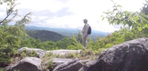
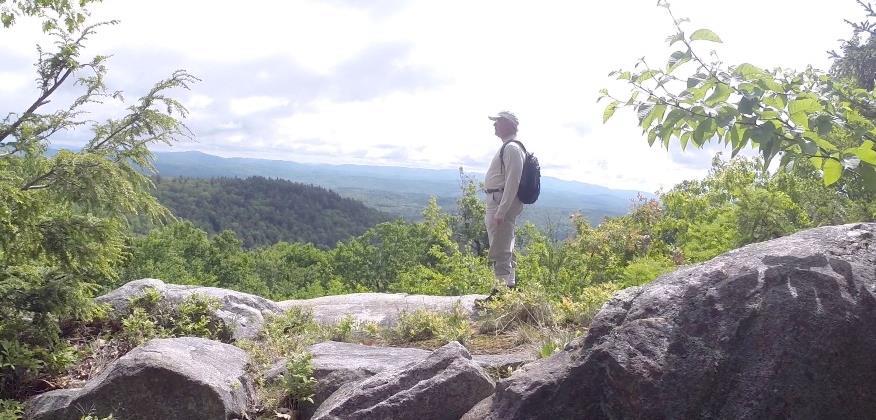
- 5 minutes from the first ledge, arrive at the second, larger ledge, with even broader views. From the highest part of the open rock, you can see distant Mount Washington at 11 o’clock. At 10 o’clock, the ridge of Moose Mountain stretches N beyond the communications tower.
- To return, look for pink tape on a tree to locate the trail back. It becomes clear you’re hiking the very spine of this mountain, a watershed divide, with the Mascoma River valley off at R and Mink Brook valley at L.
- Return to the first ledge and follow a blue arrow to return to the trail junction.
Hike Continued
- Back at the trail junction, retrace your steps to the fallen bare tree across the trail. Continue another 10 paces to a yellow sign at R for the Baum Conservation Area. At L, an orange sign with an arrow directs you to turn L onto the Ridge Trail, which appears as a smaller side trail.
- Soon the Ridge Trail swings L and slabs along the contour before heading gently downhill. Note the bristly white pine at R that has received the attentions of pileated woodpeckers. The forest floor undulates with
- the mounds and pits that betray long-ago blowdowns.
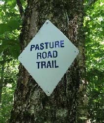 5 minutes after turning onto this trail, arrive at a junction. Bear R to follow orange flags, about 20 yards to a small hollow. Here an orange sign at L reads “Orange Ridge Trail” and at R, a white sign indicates “Pasture Road Trail.” Note the town’s blue and white trail blazes on a birch at L. This doesn’t look much like a road, but it follows, more or less, the route of a long-abandoned early “highway.”
- Turn R to take the Pasture Road Trail, which is marked with blue-white blazes and occasional blue flagging. Here, the trail is uneven and narrow but well-marked.
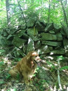
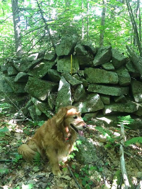
- 6 minutes from the junction, you come upon a startling sight – the imposing corner of a stone wall with a yellow pin protruding from its base – boundary markers from the 19th and 21st centuries colliding. The wall is big and blocky and encrusted with lichen. It marks the northernmost corner of the Baum Conservation Area. After the terrain you’ve just been over, it’s hard to imagine building a wall to keep sheep here – especially a wall like this!
- The trail continues L of the wall’s corner. Keep the wall on your R and a sharp eye out for painted blazes and blue flagging. The wall oddly ends, then after the trail twists near an outcrop, a section of wall appears again. There’s a nice growth of bunchberry and lowbush blueberry on the forest floor.
- 8 minutes from the pinned wall corner, the trail parts company with the wall, which heads downslope. You continue straight, following blazes carefully. A short section of wall shows up again (what was the wall builder thinking?). Keep following the blue flagging and trust your feet.
- 3 minutes later, bear R downhill onto a clearer path, down to a flat in a hemlock grove. Here, the trail bears R and is marked with simple blue painted blazes. Arrive at an opening with a dramatic view up to the ridge you may have just visited.
 The trail continues on a narrow, rocky path for another 5-7 minutes arriving abruptly back at the Baum Conservation Area’s Blue Loop Trail, the now-familiar wide grassy path.
- Turn L onto the easily followed trail and soon cross a streambed. Depending on recent weather, it may be dry, but it still has a watershed address! It’s an unnamed tributary of Lovejoy Brook, a tributary of the Mascoma River. We think it should be Baum Brook.
- 10 minutes after joining the Blue Loop, cross another tiny stream. A path comes in at L – this leads to the Baum Cabin. Continue straight, head slightly uphill, and 2 minutes later you’re back at the meadow with your car in sight. As you head down to it, don’t forget to look for wild strawberries in the grass!

Note – Baum Cabin, 1/3 mile north of the parking area, is open to all by reservation with the Dartmouth Outing Club. Jim and Carol Baum gave the cabin to the DOC in 2008, thoughtfully including funds for its upkeep. The two-room cabin sleeps 6.
Learn More
