Hike information and map – full PDF
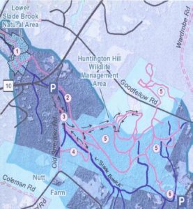 Driving Directions
- From downtown, head N on Rt. 10 past Hanover Conservancy offices
- Continue on Route 10, 3.3 miles past the N rotary
- Turn R on Old Lyme Rd. and drive 0.2 miles to a sharp bend.
- Park on R on gravel shoulder at sign for Upper Slade Brook.
What You Should Know
- Foot travel only, except for Old Spencer Road.
- Dogs are welcome but must be under close control.
- This loop hike passes through the Barnes Estate, owned and managed by Dartmouth Hitchcock Medical Center, before reaching the Huntington Hill Wildlife Management Area, a major privately owned parcel protected by a conservation easement held by the NH Fish and Game Department.
- Trails are marked in some places; plans are being developed for a new trail map.
Hiking Directions
- A sign bearing a white arrow with yellow lettering directs you to Upper Slade Brook on a path leading in to the woods. Begin your hike here.
- In a few yards you’ll pass over a narrow wooden footbridge, built by the Hanover Conservation Council (now Conservancy) and town volunteers in 2000. This crossing replaces an earlier one – below at L is the old stone abutment for the bridge that once carried Old Spencer Road over this stream. This road, built in 1816 to link Old Lyme Road with Dogford Road, was discontinued subject to gates and bars in 1932.
- Follow Old Spencer Road through the woods and up the hill. This is part of the former Barnes Estate, now owned by DHMC. In 2017 this area was logged significantly.
- About 7-8 minutes from the bridge, you’ll reach a junction marked with a yellow-lettered sign. Old Spencer Road continues straight uphill. Bear L onto the Bridle Path. It has been used recently as a skid trail, but quickly narrows and you’ll soon hear the music of Slade Brook at L.
- After 5 minutes’ walk from Old Spencer Road, a sturdy wooden bridge comes into view as you cross onto the Huntington Hill Wildlife Management Area.
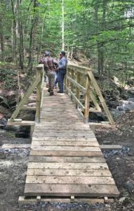 Pause on the bridge to admire both the workmanship and the partnership that built it in May-July, 2017. A determined team of 20 volunteers, led by Hugh Mellert and the Hanover Conservation Commission’s Trails Committee, built the bridge with permission of the private landowners and help from the Upper Valley Trails Alliance, Hanover Public Works, Hanover Conservancy, Cardigan Mountain Highlanders, DHMC, neighbors, and hikers who happened by and jumped in. Funds for materials were donated and the 250 person hours of labor were free. This new bridge replaces one that’s been gone for 50 years, and provides a safe and valuable connection to the network of trails on Huntington Hill.
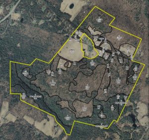
- Huntington Hill Wildlife Management Area (outlined in yellow on this forest stand map) is managed for recreation, timber, and wildlife habitat. The NH Fish and Game Department holds a permanent conservation easement on 464 acres of privately owned land here, and also on a 31-acre piece connecting it to Hanover Center Road, where the Hanover Conservancy holds a secondary easement. Forests and vegetation cover are highly variable, with deciduous, mixed, and coniferous forest types. Hemlocks dominate the brook valley (lower L). Much timber stand improvement has been done over the last 40 years under the guidance of professional foresters.
- Now turn your attention to the brook itself, and the fascinating variety of rocks composing its bed. Water-worn granite alternates with leaves of uplifted, slanted sedimentary rock that speak volumes about the deep geological history of this place.
- Two trails meet at the far end of the bridge. Bear L onto the wider of the two (you’ll come back on the other one) and head steadily uphill through a pine/hemlock forest. Faded pink flagging marks the route.
- About 10 minutes’ walk from the bridge, you reach the top of a rise where the Barnes Trail comes in at L by two large white pines. Another wooden sign with yellow lettering confirms your location. Continue straight for Goodfellow Meadows. Just ahead, another trail junction is visible. You’ll take that path on your way back.
- 15 minutes’ gentle steady walk uphill from the bridge, a trail comes in at R. Continue straight toward the opening that appears ahead. An orange diamond with arrow is posted at L, guiding your way forward.
- Pass briefly into a brushy wildlife opening of berry bushes and popple. Think like a bear and keep an eye out for ripe fruit before reentering the woods. Places like this are also excellent habitat for hares.
- In 6 more minutes’ walk, arrive at an open meadow bounded on the far side by a stately line of trees. A minor trail comes in at R – you’ll be returning on that trail to this point later.

- Walk straight through the meadow, a stark contrast to the piney woods below. The meadow is filled at this season with golden black-eyed Susans and goldenrod, white yarrow and Queen Anne’s lace, and deep blue cow vetch among the grasses. Wildlife appreciate openings like this, vestiges of the much more open agricultural landscape that once existed here in New Hampshire. Listen for the conversational trill of the song sparrow.
- Nearing a small red maple at L, note the barely perceptible shift in the tilt of the land beneath your feet. You are crossing the watershed boundary from Slade Brook behind you to the watershed of Pingree Brook, ahead.
 As you approach the wall of tall trees at the far end of the meadow, a break in the trees appears and you arrive at an opening in the stone wall. Beyond stretch a grand, wide, rolling hayfield and wonderful views to the west and northwest. On the day we visited, newly mown hay was being turned to dry and the air was full of its sweet scent. While a woman driving a tractor was managing this task today, we could easily imagine a horse drawn tedder (R) doing the job a century ago.
- While it’s hard to keep your eyes off the distant horizon, wrest them away to the stone wall close by. Among the larger stones are many smaller fist-sized ones, clues that the land growing grass today was once cultivated, prompting the farmer to remove and dump here any small stones that might damage his equipment or discourage seedlings.
- Turn R and head up along the edge of the hayfield close to the tree line.
- You’ll pass another break in the stone wall, but continue until the 19th century barn comes into view and you reach a sturdy post carrying a bluebird house and the familiar orange diamond with arrow. Views are even broader here. Imagine a time when these hills were 85% open sheep pasture and cropland, rather than 85% forested. In 1840, when Hanover’s human population was about 2,600, its sheep population was 11,024!
- A low yellow-painted iron post by the stone wall marks your turn back into the woods here. Turn R again onto a well-worn path that follows the wall back in the direction you just came. From this vantage, it’s easy to read the former farming use in the strands of barbed wire laying over wider sheep fencing. A line of fine old maples punctuates the wall, testifying to the passage of time on this farm.
- As the trail swings gently up to the L, sharp eyes will find the hood of a 1930s-era truck, another remnant of farm days past. The trail moves away from the field and wall and back into the Slade Brook watershed. Continue straight and head WSW and eventually S, gently up. Occasional flagging appears at R.
- 15 minutes from the field, an opening appears through the trees; just before reaching it, turn R onto a narrower trail just past a handsome straight-boled red oak at R.
- A few yards later, this link ends at a T; turn R.
- 3 minutes later, you arrive back at the first open meadow. Look for the small red maple dead ahead. Stop and admire the views you couldn’t see when you first traversed a lower part of this field.
- Paths diverge here following the forest edges; you bear L, noting blueberry bushes at your feet, and pass along the edge of the meadow before quickly regaining the shelter of the woods.
- 5 minutes later, rejoin the trail at the end of the meadow. Turn L and retrace your steps downhill, bringing you in 10 minutes back to the yellow painted sign for the Barnes Trail. If you’re in a very big hurry, you can take this trail to return directly to your car (about 12 minutes), but you’ll miss a nice treat (20 minutes, not including time lingering by the brook).
- To continue your hike, turn to face uphill and after 15-20 paces, turn R onto a new trail that largely follows the contour after a short log crossing of a small drainage. The trail soon takes on the look of a very old woods road, with a sunken bed just wide enough for a cart. The old road starts down into Slade Brook’s hemlock-shaded valley.
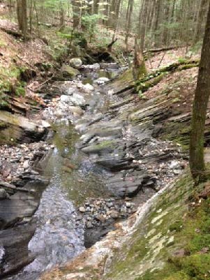 5 minutes from the last junction, you reach the brook at a footbridge constructed in September, 2018 by Hanover Trails Committee volunteers and the public-spirited landowner. Today, our route keeps us on this side of the brook.
- Turn R and follow the brook down through its steep-sided valley, noting how tree roots hold the streambank in place. In some places, you can see where the brook makes several channels during high water, and then recedes to the lowest of them as waters subside, rearranging its bed every time. A thrush’s song plays a duet with the water’s music.
- Watch closely for a shift in the trail up to the R under a tipped hemlock as the trail leaves the brookside to avoid a section of uplifted ledges. Occasional orange arrow signs point the way, but you need only to keep the brook on your L. It seems a privilege to be accompanying this little brook on its trip to the Connecticut River, spilling over tiny waterfalls and enlivening occasional pools as it tumbles on its wood-strewn way. If you brought a snack with you, find a likely looking rock perch to enjoy it now.
- 6 minutes from the old crossing, return to the new bridge. The trail you took on the way out comes in at R.
- Past the bridge, you’ll know when you’ve returned to DHMC land when logging slash appears by the trail. Limbs and branches are left behind to return nutrients to the soil and feed the next generation of trees.
- 3 minutes from the bridge, arrive again at Old Spencer Road. Turn R and head down 4 minutes to the lower bridge and your car.
Please respect the generosity of these landowners by leaving no trace of your visit and enjoy the memories and photographs you take home.
In 2004, Northern Woodlands magazine carried this feature story about Huntington Hill.


